


During our visit to Alaska in September of 2008, Daria and I had a chance to fully hike and explore the West Glacier Trail in Juneau, Alaska. Many local residents consider this to be the best trail in Juneau, but most tourists remain unaware of its existence. We found out about it by researching hikes in Juneau that would provide the best views and access to Mendenhall Glacier. On a previous trip to Alaska three years earlier, I had spent some time walking around the Mendenhall Visitor Center and trails close to it. Those trails did provide for some nice views, but with Mendenhall Glacier now receding at an astonishing 600 feet per year (just a few years ago it was only receding 60 feet a year), I wanted to search out some new views of this spectacular place that most people will never see in their lives. And the West Glacier Trail did just that. The West Glacier Trail is 3.4 miles one-way (or 6.8 miles round-trip) and has an elevation gain of 1,300 feet. The cheapest way to get to the West Glacier Trail is to take the Juneau Capital Transit Bus from downtown. There is a convenient bus stop located outside of the Juneau Public Library. The bus will drop you off about 45 minutes later at the Montana Creek Road bus stop (make sure you tell the bus driver this is where you need to go, and don't get off at the Mendenhall Glacier bus stop or you'll have a lot longer walk). Walk up Montana Creek Road and keep following it as it turns slightly to the right and becomes Skater's Cabin Road. At the end of this road you will find a parking lot with access to Mendenhall Lake and the trailhead for West Glacier. Shortly after starting on the trail, you will find a place where you can sign in for the hike (no longer available as of 2010). But the best way to get there is probably to just take a taxi there and then either call a taxi for a return ride to town or walk down to the bus stop.
The trail takes you through a beautiful section of the Tongass National Rain Forest with stunning views of Mendenhall Glacier and Ice Field. It's actually one of my personal favorite hikes that I've ever completed in my life. Some of the dangers to be aware of are bears, slippery rocks (since it's almost always raining or has rained recently), and glacier risks. As far as bears, we chose to do this hike without Bear Repellant Pepper Spray, but it was recommended by a park ranger I talked to in the Mendenhall office that Bear Spray is carried. The problem with not carrying it is that if you do encounter a black bear or grizzly bear and you surprise him, or accidentally come in between a mother and her cub, you are going to be in big trouble and the Bear Spray could very well save your life. (If you're wondering, it can be bought in Juneau at Fred Harvey's for $45, which is a bus stop about halfway between the Public Library and Montana Creek Rd.) The only reason we didn't carry the Bear Spray was that we were in town on a cruise ship, and ship security told us we would not be permitted to bring it back on board, which means we would have had to throw it away. Regardless, we didn't need it on this day and we had a wonderful hike. Also, there are actually two semi-trails to access the glacier. I found both of them with the help of Misty, a local girl from Juneau who helped us plan out our hike and shared a lot of important information with us. Anybody who decides to hike down to the base of the glacier to walk on it or explore the ice caves needs to read up on glacier safety before doing so. I did come across a couple horror stories of people trying to walk across the glacier without a guide or knowing what they were doing, and they found themselves in quite a bit of trouble. I did return and retake this hike in August of 2010 with my friend Charlie, as well as do a solo hike of the spur trail down to the Mendenhall Ice Caves.
The trail takes you through a beautiful section of the Tongass National Rain Forest with stunning views of Mendenhall Glacier and Ice Field. It's actually one of my personal favorite hikes that I've ever completed in my life. Some of the dangers to be aware of are bears, slippery rocks (since it's almost always raining or has rained recently), and glacier risks. As far as bears, we chose to do this hike without Bear Repellant Pepper Spray, but it was recommended by a park ranger I talked to in the Mendenhall office that Bear Spray is carried. The problem with not carrying it is that if you do encounter a black bear or grizzly bear and you surprise him, or accidentally come in between a mother and her cub, you are going to be in big trouble and the Bear Spray could very well save your life. (If you're wondering, it can be bought in Juneau at Fred Harvey's for $45, which is a bus stop about halfway between the Public Library and Montana Creek Rd.) The only reason we didn't carry the Bear Spray was that we were in town on a cruise ship, and ship security told us we would not be permitted to bring it back on board, which means we would have had to throw it away. Regardless, we didn't need it on this day and we had a wonderful hike. Also, there are actually two semi-trails to access the glacier. I found both of them with the help of Misty, a local girl from Juneau who helped us plan out our hike and shared a lot of important information with us. Anybody who decides to hike down to the base of the glacier to walk on it or explore the ice caves needs to read up on glacier safety before doing so. I did come across a couple horror stories of people trying to walk across the glacier without a guide or knowing what they were doing, and they found themselves in quite a bit of trouble. I did return and retake this hike in August of 2010 with my friend Charlie, as well as do a solo hike of the spur trail down to the Mendenhall Ice Caves.

Steve at the start of the trail:
Typical section of trail cutting directly through the rainforest:


One of the many bridges which makes river crossing easier:

Mile markers like this one keep you informed of your progress:

Cables are set up along the trail to help you up slippery rocks:

There are quite a few steep sections with stairs or switchbacks:

First view of Mendenhall Lake through the trees:

First view of Mendenhall Glacier:

Take your time up spots like this if it has been raining:

View of the glacier's current terminus and Bullard Mountain:

Close-up of Nugget Creek Falls and glacier's edge:

Zooming in for a closer view of the terminus:

There is one large stream crossing which has no bridge:
Close-up of the glacial ice as seen from the trail:


Looking through the trees in another view along the trail:

The trail continues uphill through the rainforest:

Reaching a spectacular viewpoint:

Getting close to the end of the trail:

Daria at the top:

Looking back at some of the rainforest we hiked through:

Majestic view at the end of the trail:

Looking down at the blue ice crevasses:

The view reaches all the way to Gastineau Channel:
Another glacier can be spotted above the clouds off in the distance:


End of the trail sign (after this you need to follow ribbons tied to trees):

People landing on Mendenhall Glacier by helicopter in the distance:
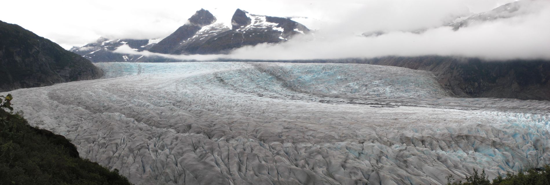
Panoramic view of the upper ice field taken a short distance after the official trail end (click to enlarge):

Looking down at the ice field from the lookout point:

A couple views with Steve and Mendenhall Glacier & Ice Field:


Picture of Daria and Steve before they headed back down during the 2008 hike:

The next 8 pictures were taken during the 2010 hike with Steve and Charlie:


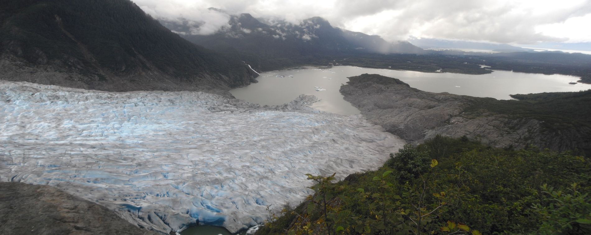
This panoramic of the Mendenhall Glaicer terminus was taken during the 2010 hike (click to enlarge):

And we leave you with pictures of Daria crossing two streams over bridges:

