


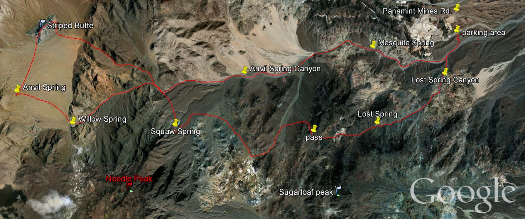
From March 18-21, 2010, six friends joined me for a backpacking trip that we were pioneering as a loop through Lost Spring Canyon and Anvil Spring Canyon. Included in our group were Shawn and Kathy, who had previously joined me in 2009 for our backpacking trip through Cottonwood Canyon and Marble Canyon. Also, Josh and Kimmi, who were recently married in 2009. Josh had previously been on countless Death Valley trips with me, while this was Kimmi's first trip to Death Valley and her first backpacking trip. Rounding out the group were Steve and his daughter Layla, also visiting Death Valley for their first time, as they looked forward to spending some father-daughter bonding time. Our backpacking route was set up to take four days, with water to be available at camp every night. Part of our route would take us through areas which have received very little visitation and absolutely no attention in guidebooks or previous trip reports. Thus, we went into the trip not knowing what our journey would bring, and not entirely sure if our route would work out and allow us to reach some of our destinations. The Google Earth map below (click to enlarge it for a better view) shows you the route we had planned out before we left. We were able to successfully follow it for the most part, with the exception of having to drop our planned peak hikes to Sugarloaf and Needle. Our Day 3 side hike to Striped Butte is contained on its own Trip Report, which you can visit elsewhere on this site.
Part 1 of 4 (Panamint Mines Road to Lost Spring via Lost Spring Canyon)
850 ft elevation gain (1,300' to 2,150')
5 miles distance (5 of 40 total miles covered)
Thursday afternoon, the plan was to meet up at the intersection of the Harry Wade Road and Badwater Road. I had just finished up my Spring trip of day hikes and would be meeting the rest of the group at that spot. To our great surprise, we all arrived at the meet-up point at the exact same time, which is very tricky considering the fact that timing and communication is difficult without having cell phone reception. Thus, nobody had to wait and we were able to immediately start driving out West Side Road and then up Warm Springs Road. After about 7.3 miles, we turned left onto the Panamint Mines Road. Being that I do not have 4wd, I was a bit concerned about how far I would be able to make it before having to park. The road had some good and bad spots, but towards the end I drove down a steep hill and started wondering how I would be able to get back up it later. I decided not to worry about it, so we all parked just before the Panamint Mines Road turns sharply to the west. After final preparations, we began backpacking up an old road which crossed over the hill and dropped down into the wash of Anvil Spring Canyon. A short time later, we found the obvious junction with Lost Spring Canyon and began heading up towards Lost Spring. The weather was really hot for the first two hours of the hike. But after that, it cooled down considerably and the rest of the trip was a lot more comfortable. The canyon eventually narrowed down and we had some nice views of prominent peaks, although Sugarloaf Peak was never visible. Towards the end of the day, the wash became choked with vegetation, plants, and trees. We also reached the flowing water of Lost Spring. After considerable debate in the fading light, we finally settled on a campground just above the canyon on a flat area where we could all camp together. That first night was extremely difficult, as the wind was fierce and a storm came in dropping just a little bit of rain. Setting up camp took a lot of patience and hard work, and also required stashing boulders in the corners of our tents to prevent them from blowing away.


Shawn driving down the Harry Wade Road on early Thursday afternoon:
Our backpacking group posing at the starting area for our trip on the Panamint Mines Road. Left to right, that's Steve H, Kimmi, Layla, Steve M, Josh, Shawn, and Kathy:
Heading up the first small slope at the beginning of our trip:
We followed this old closed road down into the wash of Anvil Spring Canyon:
Welcome to the world of backpacking, Layla and Kimmi:
The huge junction with Lost Spring Canyon. This is where we turned off and started heading up towards Lost Spring:
It was really hot during the first two hours of our hike. So hot, that some of us were hiking close to this canyon wall in order to stay in the shade and keep cooler:
Eventually, some clouds rolled in and helped cool things down:
Great picture of Kathy and Shawn with a prominent peak behind them. That's not Sugarloaf Peak, as Sugarloaf is actually set further back in the range and is not visible during the hike:
Josh and Kimmi in good spirits during our first day of backpacking:
Layla found this animal bone in the wash. She was lots of fun and really enjoyed the trip:
Heading further up Lost Spring Canyon as it begins narrowing down:
Josh and Kimmi pressing on as we were getting very close to Lost Spring:
Steve H, Layla, and Steve M trying to navigate through the thick overgrowth of Lost Spring:
Layla looking down as she discovered the first appearance of flowing water from Lost Spring:
And finally, this is the area where we set up camp for the night. It was above the canyon wash on a nearby hillside which had a flat area. This picture was taken very early the next morning:
Part 2 of 4 (Lost Spring to Squaw Spring via pass)
1,200 ft elevation gain (2,150' to 3,350')
10 miles distance (15 of 40 total miles covered)
Friday morning we woke up to a pleasant change in weather-- calm air and comfortable temperatures. Steve M and I spent some time exploring the Lost Spring Canyon narrows and waterfall area, while the others were still waking up and cooking breakfast. It was a really pretty and scenic area, and it was too bad the rest of the group did not get the opportunity to see it. After we packed up, we found some burro trails which bypassed the canyon narrows and thick brush which had been giving us so much trouble. We continued heading up Lost Spring Canyon and had some interesting experiences. We took one wrong turn and had to backtrack, we had to climb a small dry fall, we found some parts of a rocket or missile on the ground, and then we crossed up to the pass. As nobody had ever published anything about attempting this route before, all of my planning had been done on topographical maps and Google Earth. It had appeared that the route would go through, but you never actually know until you get there. Fortunately, there were no major surprises as we headed up to the pass, with the exception of finding a desert horned lizard and a frightening scorpion on the summit. We were able to drop down from the pass without too much trouble and follow a small side canyon with crystals scattered in the wash everywhere. (The same crystals which can be found in the Crystal Hills of Death Valley-- see that Trip Report for more information.) We eventually followed another burro trail out of that side canyon and down towards Anvil Spring Canyon. It was a great relief when we finally arrived at Squaw Spring and found flowing water in 3 different locations. We set up camp up high next to Squaw Spring on a flat area along the old road.


Waking up to an incredible change in weather after a rough night:
Looking further up Lost Spring Canyon from the spot where we camped:
Entering the fantastic short narrows of Lost Spring Canyon:
Notice the high walls which come very close together here:
And Lost Spring flows directly down the middle of the wash through the narrows:
Notice there is quite a bit of water flowing through here:
This is the lower fall where water is pouring over abundantly:
And this is the upper fall which is just above it a short distance:
Beautiful green trees were in the narrows and falls area of the canyon:
Outstanding view looking over the trees and further up Lost Spring Canyon:
Two of our backpackers bypassing the thick plant growth in the wash:
Now we are all back in the canyon wash and heading further west:
Josh, Kimmi, and Kathy hiking together and enjoying some great conversation:
We reached this area where there was green grass and barren trees crowding the canyon:
Kimmi and Josh entering another short narrows section:
Layla climbing the first dry fall she has ever gone up in her life. An impressive feat at 13 years of age. Her dad is up above, ready to extend a helping hand if necessary:
Steve H climbing the same dry fall a few minutes later:
Nearly to the point where we would begin the climb out of Lost Spring Canyon:
Taking a quick breather before beginning the ascent to the pass:
We found this missile or rocket which had crashed into the hillside on our way up to the pass:
Close-up of the very heavy tip of the rocket:
On the edge of the long tube part there were military markings, along with the word "Rocket":
In the next two pictures, Josh and Steve decided to pick up the crashed missile parts for pictures. Probably not a good idea, guys, if you want to keep your hands and bodies intact:
Final stretch heading up to the pass. The climb from the canyon floor to the pass only took about 15 minutes:
On top of the pass now and looking down into the side canyon below which was our next destination:
Beginning the long descent down into the side canyon. We were about to drop 500 feet of elevation:
Steve and Josh together on a backpacking trip in Death Valley for the first time since Panamint City in April of 2006:
Picking up a friendly desert horned lizard along the way:
And avoiding an unfriendly scorpion in the same area:
Our group carefully making their way down some steep terrain:
Just about to the side canyon, with the pass in the background:
Finally dropping into the side canyon and heading southwest for a short distance:
Steve M heading up the side canyon. At this point, everybody was picking up the crystals we were finding in the wash and examining them:
Off in the distance we could see the source of the crystals, which were the light colored hills seen here:
We only hiked in the side canyon for about one mile before heading back up to take a cross-country route towards Anvil Spring Canyon and Squaw Spring:
Crossing over a small hill and heading back down while following burro trails:
Shawn set the pace and we tried our best to keep up. Shawn is spending several years completing the entire Pacific Crest Trail between Mexico and Canada. To date he is about 1/2 way done. For him, this backpacking trip to Death Valley was a way to get in shape and train for his upcoming more serious hikes:
Passing by some burros who didn't seem too thrilled to be seeing us:
I had to keep reassuring the group that we were not lost and that Squaw Spring would soon be appearing. Sure enough, we finally caught sight of Squaw Spring off in the distance:
Layla handling another day of backpacking with ease:
Catching one final break while Shawn and Steve M were searching for the water sources around Squaw Spring:
We found 3 different places which had flowing water. Shawn is seen here pumping water out of one of the springs:
Shawn boiling water for the group and helping all of us to prepare our backpacking dinners:
A look at our camping spot for the 2nd and 3rd nights of our trip. This was along the old road just before it reaches the green trees of Squaw Spring:
This was the view I had out of my tent down into Anvil Spring Canyon. Definitely a pretty spot:
And the sun began setting on another day in Death Valley:
Part 3 of 4 (day hike to Striped Butte)
1,394 ft elevation gain (3,350' to 4,744')
15 miles distance (30 of 40 total miles covered)
Saturday was set to be our day off from backpacking and also the trip highlight. We were going to do a loop day hike to the summit of Striped Butte and back. None of us had ever been in Butte Valley before, so it was going to be an interesting experience to walk through it for our first visit, rather than driving through it. For all of the details on our 15 mile day hike to Striped Butte, please visit the separate Trip Report under the Panamint Mountains section. There were just too many photos and things to share with you, and not enough room on this page. Shawn, Kathy, Steve M, Layla, and Steve H all did the Striped Butte day hike, while Josh and Kimmi took the day off completely and relaxed around the Squaw Spring area, where they did a little bit of exploring.


Waking up to Day 3 on our backpacking trip. Shawn is taking in the sunrise while he waits for the rest of the group to wake up:
In the next two pictures, Layla is playing with rocks while she waits for everybody to finish their breakfast and start the hike to Striped Butte:
Josh and Kimmi spent the day exploring the area around Squaw Spring. They found some nice viewpoints of the landscape:
In the evening we were all back together at camp. Some played cards, while others went to sleep early:
Part 4 of 4 (Squaw Spring to Panamint Mines Road via Anvil Spring Canyon)
2,050 ft elevation loss (3,350' to 1,300')
10 miles distance (40 of 40 total miles covered)
Sunday morning it was time to complete our trip and head back to our vehicles by way of rarely hiked Anvil Spring Canyon. Anvil Spring Canyon turned out to be a lot more interesting than I was expecting. On Google Earth, the canyon looks wide and possibly boring. But from the grand vistas, to the herd of burros, the two desert iguanas, the varying rock types (including decomposing granite), the unexpected flowing water hidden deep inside Mesquite Spring, the surprise mine that we walked by, to following the old road for half the hike… it all added up to an awesome day. I think we all enjoyed it greatly, even though it seemed like everybody's favorite moment was finally catching sight of that old road which climbs out of Anvil Spring Canyon and led back to our vehicles. In creating this backpacking loop from scratch, I needed the route to meet 4 criteria- (1) water availability, (2) interesting scenery and destinations, (3) ability to hike as a loop, and (4) lower elevations. Once our trip had been completed, I realized that all of the criteria were met perfectly and it truly was a great accomplishment to see this rarely visited area.
This was the first view we had of Striped Butte during our amazing day hike. To see more pictures and read about it, you will need to visit the report for Striped Butte:


Layla heading down from camp on Sunday morning to begin the 10 mile backpacking journey:
The rest of the group heading down and following the old road:
Steve looking a long distance down Anvil Spring Canyon:
If you look closely where the group is walking, you can see the old road which we were able to follow for several miles:
Another view of the overgrown long closed road which heads down Anvil Spring Canyon:
The entire first half of the hike was spent walking through the wide open spaces of the canyon. Far up ahead you can see where it starts to narrow down:
Check out this huge white band across the mountain side:
Once we got into the narrower sections of Anvil Spring Canyon, we found thick brush which made fast progress impossible:
Usually we would stick to the left or right side of the wash, where a trail would push through the brush for a while, before it crossed over to the other side or disappeared:
Josh and Kimmi backpacking together on a beautiful Sunday morning:
One of the biggest surprises of the entire trip was when we found an abundance of flowing water in Mesquite Spring. This spring was supposed to be dry:
The group continuing down Anvil Spring Canyon navigating through the brush:
The first of two desert iguanas which we passed during the day:
Another section of Mesquite Spring with some bare trees growing in the canyon:
Passing by some huge rock walls in Anvil Spring Canyon:
Layla getting her picture in front of the mine we stumbled across in the canyon:
Looking deep into the mine, which we did not end up exploring:
Below the mine we found a huge tailing and rail pieces stretching out:
And finally we made it to the old road which leads back to our vehicles:
Dropping down the final section to where we parked on the Panamint Mines Road:
Steve attempting to drive back up the steep hill which he had been worrying about for the past four days. It wasn't easy and took several attempts, but we finally made it out: