


Epaulet Peak had not been a destination on my To-Do list or even remotely on my radar before my Winter 2010 Death Valley trip. But when making final plans for that trip, my friend Charlie asked if I would be interested in hiking Epaulet Peak. At first, I was a bit apprehensive upon seeing some photos of the hike from other trip reports. I did not want to get caught up in a hike that might be relatively boring without a lot to see. It was then that Charlie explained the route to me, that the focus would not be on Epaulet Peak itself, but on the colorful badlands below it. After checking out the potential scenery on Google Earth, I was sold on it and ready to go. And the hike did not disappoint. We parked at Rhodes Spring and did Epaulet Peak as a loop hike. We found some interesting things while hiking up to Epaulet Peak, as we passed through a smaller canyon with some water in it and then followed a ridge up which had some nice rock formations and got quite steep. From Epaulet, there were nice views of Telescope Peak, the Panamint Mountains, Greenwater Valley, and Mount Charleston. But it was on the hike down where we saw some very impressive scenery. We dropped into a canyon which we had targeted on Google Earth and our topo maps. It had some nice narrows and several flowing waterfalls. We even discovered a lush green spring which hardly any people probably know about. But based on the evidence we came across, the Bighorn sheep certainly are aware of it. We hiked the final hour or so in pitch black darkness and had a tough challenge as we had to bypass two major waterfalls which we were not expecting to come across. It appears that water probably flows consistently from the spring in the small canyon we hiked down in. But we happened to be there after a major rainstorm, which no doubt contributed additional water and made the waterfalls even more pretty. The word epaulet is pronounced ep-uh-let and is defined as "a shoulder ornament, especially a fringed strap worn on military uniforms." I was told that Epaulet Peak was named because from a distance the rock layers making up the peak resemble an epaulet. The Google Earth map below is turned towards the West to show our entire route in a more practical way.


Rhodes Spring was the starting point for the route which we took to Epaulet Peak. Traditionally, the hike is started from the Greenwater Valley Rd.:
Following an old closed road at the beginning of the hike:
Hiking on a compact hard dirt wash upon leaving the old road:
Flowing water soon appeared in small dirt channels. A recent rainstorm in the park was no doubt responsible for this water:
First look at the colorful badlands and Epaulet Peak at the top left:
Looking at some interesting rock formations in the distance. From the spot where this picture was taken, we turned to the right and went around a hillside:
After wrapping around the hillside, we were now headed due north towards Epaulet Peak:
Joe and Charlie headed up a small side canyon which we began following:
Charlie next to an 8 foot flowing waterfall which we encountered in the side canyon:
Looking back down the side canyon, you can see that water was flowing for quite some distance:
A close-up of the water as it flows over the waterfall that Charlie was standing next to:
When the side canyon ended, we took the nearest ridgeline up. Here Charlie is pausing at the first bump in the ridge:
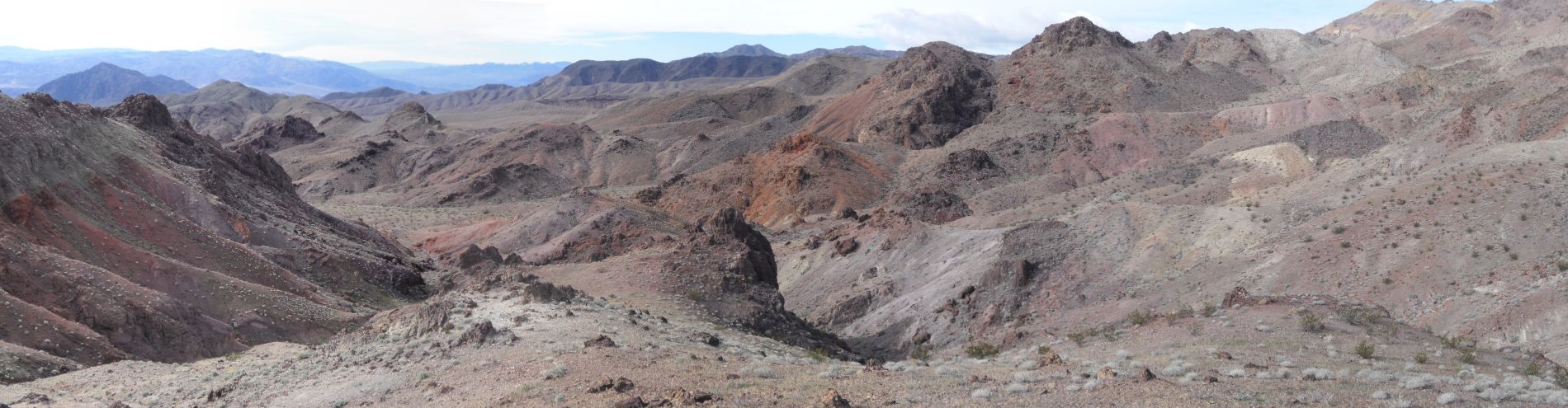
Panoramic of the colorful badlands below Epaulet Peak taken from the first bump in the ridge (click to enlarge):
Looking up at the ridgeline we would need to follow for the next couple hours:
The first part of the ridge had these cave like openings in the red and black rock:
Regularly changing terrain during the hike uphill:
A huge rock outcropping that we had to navigate around to the left:
Looking down on the colorful badlands as we made progress uphill:
A majority of the hike was steep, but not too difficult or strenuous:
One of the many small arches which we found during this portion of the hike:
Zooming in on the badlands down below as they got further away:
We had to head to the far left point here to continue, so I side-hilled this part while Joe and Charlie hiked to the peak on the right and then crossed over:
Nice view of snow-capped Mount Charleston in the distance above Las Vegas. Mount Charleston is the 8th highest peak in Nevada at 11,916 feet:
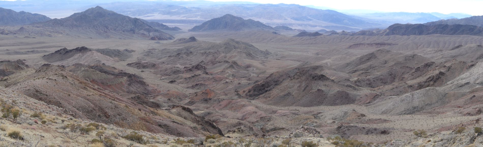
Another panoramic view of the badlands below Epaulet Peak as we were further up the ridge (click to enlarge):
On the side-hill portion of the hike. I usually don't cut across like this, but this time it seemed to be easier:
Looking down towards the badlands, the red colors really stand out:
Working along the ridgeline about 2/3 of the way up to Epaulet Peak:
Nice scenery as we reached the next bump on the ridge and turned dramatically to the east:
We would head to the right (east) here and then take a final turn to the left (north) to head towards Epaulet Peak as seen in the distance:
From this spot we had a nice view of the heavily flowing Amargosa River (front light spot) and Owl Lake (back light spot):
Dropping back down a bit before beginning the steepest climb of the hike:
And this was indeed the steepest climb of the hike. It was slow going as we carefully made our way up:
Charlie and Joe navigating their way through a boulder field:
Two more views of the boulder field which we hiked and climbed our way past:
The summit stands out majestically from the surrounding area:
Looking back down at the boulder field we crossed through:
Steve successfully getting past the boulder field to a rest point:
Joe and Charlie pressing on towards the summit:
Final path to the summit is across a very flat area that was a bit steeper than it looked:
Charlie and Joe just about to the summit now:
Arriving at Epaulet Peak with Rhodes BM marking the spot:
A nice view to the northwest of Telescope Peak and the Panamint Mountains:
The next five pictures were taken showing various views into Death Valley and Nevada from Epaulet Peak. The views go clockwise starting by looking north:
Joe signing in at the peak register. This was his 2nd major peak hike in Death Valley (the 1st was Desert Hound Peak in 2007):
Joe and Steve's sign in page in the register. Notice we were only the second group of 2010:
Steve, Charlie, and Joe on Epaulet Peak on December 26, 2010 as the sun begins getting lower in the sky:
A picture of Steve standing on the edge above the badlands:
Heading down from the peak now. We weren't backtracking, but rather loop hiking out a different route:
This was the targeted canyon that we wanted to get into for our descent:
After first dropping into the canyon, we headed back up to see what we had missed and found an incredible section of narrows:
Looking out of the narrows at the sky above us:
These narrows had very high walls which closed in on us:
Good thing we didn't try to drop into the canyon at its head. As you can see here, there is a massive dry fall at the end with a boulder wedged in at the top:
Heading back down the narrows and admiring the scenery:
One final picture of the narrows before we got back to the spot where we had dropped in:
Charlie and Joe taking a very short break as we began heading down the side canyon:
The canyon remained narrow and at times we would have to bypass small dry falls:
Coming across a completely unexpected lush green spring:
This spring really stands out in contrast with the surrounding desert landscape:
Looking up canyon from the spring at another dry fall which we had bypassed earlier:
Passing by a heap of boulders resting in the canyon:
Joe making his way down the canyon:
In the next three pictures you can see massive boulder jams which we had to work our way around:
Coming across a pretty pool of water cascading in from the spring which flowed through much of the canyon:
And a beautiful 15 foot two-stage waterfall over polished purple rock:
Two more pictures of the 15 foot waterfall:
Past the waterfall, the water continued flowing through a channel in the purple rock:
Just when we thought it couldn't get better, we encountered a waterfall which was 40 feet high:
Three more pictures of the gorgeous 40 foot waterfall:
The canyon stayed narrow for us as the sun went down over the horizon:
And we end with this picture of another small waterfall. A short time later it got too dark for pictures and we finished the hike by flashlight: