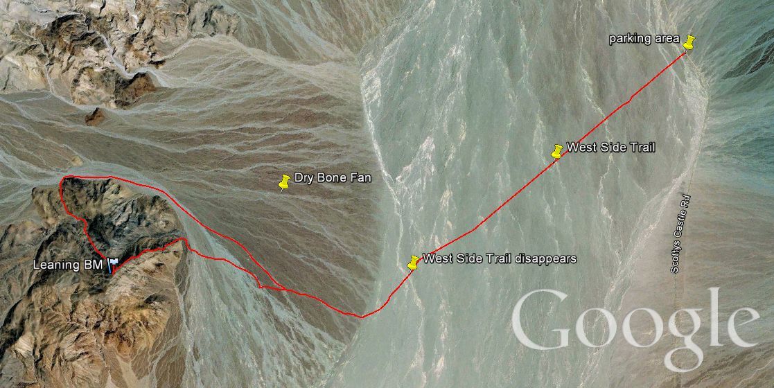
My hike to Leaning BM came about on my Fall 2011 trip because lately I have been trying to include hikes to obscure BMs (or benchmark peaks) on each Death Valley trip. Leaning BM was suggested to me and I happily agreed upon examining the route closely. What interested me was finally having a chance to hike the West Side Trail across the Mesquite Flat area north of Stovepipe Wells. The West Side Trail is the old West Side Road, which has long been closed to vehicles. I had seen the West Side Trail from a distance while hiking up to the mouth of Red Wall Canyon. It just looks like a straight line going out across the desert. The straight trail is also clearly visible on Google Earth. To reach Leaning BM (or Lower Dry Bone Canyon), it's actually over a mile shorter to park on Scotty's Castle Road further south and hike cross-country across the desert. However, it will probably take you longer due to the uneven terrain, endless drainages, and rocky areas you will have to painstakingly work through. In stark contrast, the West Side Trail is a nice and comfortable direct walk across the desert with no obstacles. You can just relax and enjoy the beautiful desert scenery of the Mesquite Flat area, Cottonwood Mountains, and Grapevine Mountains. Besides being able to walk 4 1/2 miles of the West Side Trail (before it temporarily disappears for a while), I also was interested in this hike because it would give me a chance to hike up the Dry Bone Canyon Fan. The first time you hike up a major canyon fan, it's hard to know the best and easiest route of hiking. But by the time you have hiked both up and down a major canyon fan, you probably have figured out the best route with the least amount of opposition. And that will help me in the future, when I finally get around to hiking into Lower Dry Bone Canyon and the Dry Bone Main Side Canyon some day. Leaning BM is a very interesting peak. The rock of the mountain is mostly striped and composed of sharp and crumbling pieces. So it's not a very nice place to take a fall. But from the summit of Leaning BM, great views are possible of Mesquite Flat, the Mesquite Sand Dunes, the Niter Beds, Tucki Mountain, the mouth of Dry Bone Canyon, White Top Mountain, Leaning Rock BM, Mount Palmer, Thimble Peak, Corkscrew Peak, and the mouths of Red Wall Canyon, Palmer Canyon, Fall Canyon, and Titus Canyon. That's quite a long list of great things to see, so you can see why I highly regard Leaning BM as an excellent hiking destination. It's 7 1/2 miles from the parking area (which is along Scotty's Castle Road near the same place where you park for a hike into Red Wall Canyon) to the summit of Leaning BM with an elevation gain of about 1,900 feet. Click on the Google Earth map below of our route to enlarge it.

Parking in the vicinity of mile marker 19 along Scotty's Castle Road and looking towards Leaning BM far in the distance:

The old West Side Road is now the West Side Trail and is a great path for hiking. The trail starts almost right from the road:

Notice how there are some rocks on the trail, but there is a clear and easy path to walk through:
Looking back at the Red Wall Canyon fan. If you've hiked up to Red Wall Canyon, then you have had a clear view of the West Side Trail and perhaps you wondered where it went:


Looking directly towards The Cauldron, which separates the mouth of Palmer Canyon (left) and Fall Canyon (right):
Continuing along the 4 1/2 mile trail. Hiking in the desert doesn't get any easier than this:


Notice that the trail goes on as far as the eye can see:
The trail eventually disappears for a while (but then reappears somewhere in the Niter Beds). Here we have reached the end of the trail and are now hiking cross-country:

View up the wash of Dry Bone Canyon towards the similarly named Leaning Rock BM:

Cutting across the Dry Bone Fan as much as we did was probably a bad idea, as you can see here. We should have continued around the base of the fan and then headed up:


Looking to the northwest along the ridge of the northern Cottonwoods:

Dropping into some major drainages on our way to the base of Leaning BM:
As we got closer to Leaning BM, it sure looked like the ridgeline would be rugged and tough to hike:

Getting close to the base now, we could see a clear but steep path up the first part on the right side:


The striped crumbling rock which Leaning BM is mostly composed of:
Looking far across Mesquite Flat at the Grapevine Mountains:


Time to begin the actual hike up the mountain, after hiking a little over 6 miles to get to this point:

The first of many good views we would have of Tucki Mountain:

A close-up of some of the unusual rock which we found on this mountain:

After the first section, we wrapped around further to the right here:

The views across the desert continued to get better as we gained more elevation:

An even steeper and more challenging section was approaching:

Charlie hiking along the rocky area above while I sidehilled a section:

When we attained our first major bump in the ridge, we had our first outstanding view towards central Death Valley:

Charlie in the midst of the striped rock boulders scanning the area with binoculars:

From here we could see several paths to reach the next major bump, but we decided to stay to the right once again:
Tucki Mountain with the Niter Beds (dark patches on the white desert ground) below us:


Looking back at the base where we started and the bottom of the Dry Bone Fan:

These pretty cliffs were on the peak which was across from Leaning BM (and is actually a little bit taller):

Looking back at our path once again, with the side canyon dividing Leaning BM from the peak next to it:
Picture of Steve about halfway up Leaning BM with the Grapevines in the background:


The next part of the ridge hike wasn't as bad as it had looked from below. Just more staying to the right of the edges:

We could finally see our final destination peak in the distance:

Looking across at Leaning Rock BM and the head of Dry Bone Canyon:
The mountainside of Leaning BM is one massive rock which is actually quite spectacular to look at:


An excellent view of the Niter Beds from this spot. I still have never hiked out to them to check them out in person:

Arriving at the official summit of Leaning BM and finding several benchmarks in the rock:

Steve taking a self portrait with the main benchmark of Leaning BM:

Looking due north from the summit. The ridgeline seen here is actually that of the neighboring peak:

View to the northeast of the Grapevine Mountains:

Here we have Palmer Canyon (left), Fall Canyon (middle) and Titus Canyon (right):

The Niter Beds of Mesquite Flat as seen from the summit:
A majestic view of Tucki Mountain looking to the south:


A maze of smaller canyons and washes to the southwest:
Leaning Rock BM (left) and White Top Mountain (right) can both be seen here:

A panoramic of the Dry Bone Canyon wash area as seen from Leaning BM (click to enlarge):


Steve on the summit of Leaning BM:
Steve with the beginning of Lower Dry Bone Canyon directly behind him:


A picture of the actual summit of Leaning BM

An excellent view of the face of Mount Palmer in the Grapevine Mountains:

Special views of both Thimble Peak (left) and Corkscrew Peak (right) can be seen from here:

A nearly 2,000 foot drop from the summit of Leaning BM to the desert below:

Telescope Peak is also visible from this spot:

Looking directly across the face of the mountain which we hiked up (along the other side):

Instead of backtracking down the mountain, we decided to loop around the nearby peak to see some more scenery:

Charlie can be seen far below hiking in the wash. He took the lower route, while I stayed on the higher route and sidehilled:

View of this area in the Cottonwoods as we hiked towards Lower Dry Bone Canyon:

We soon hit the wash and it was time to loop back downhill. This would be as close as we would get to Lower Dry Bone Canyon on this hike:

Nice walking downhill as we headed back towards the ridge we had ascended earlier in the day:

Charlie heading down the Dry Bone Canyon wash:

The sun was setting on Mount Palmer as we headed back towards the car: