


(Note prior to reading-- To get the full understanding and appreciation for the area being discussed here, you will need to first read our Trip Report for Tin Mountain, as that is part 1 and this is part 2). When we left off on the Tin Mountain report, we had just returned to camp at midnight following a sunset summit of Tin Mountain. Back at camp, I was the only person who had accepted the extra weight and packed my tent. Thus, I pitched my tent and went to sleep inside, while everyone else rolled out their sleeping bags on the ground and slept under the stars. We were hoping to wake up early the next day, as we knew the summer heat would be an even bigger factor than the day before. This was because we would be dropping as low as 4,800 feet, a potentially very uncomfortable elevation during the summer. We didn't get up quite early enough, but we finally packed up and began backpacking down the canyon we were in. According to my research back home, our canyon would end in impassable dry falls. So we knew we would have to cross over into the next canyon over, which happened to be the canyon that drops down from Yashiro Spring. Eventually, we made the crossing and dealt with a couple of small issues, including dodging a snake and taking a slightly challenging bypass a while later. We wound up at Bighorn Springs, which had a lot of greenery and a little bit of surface water. The surface water was kind of hard to find, but when I heard lots of birds chirping and singing, I knew the water had to be there somewhere. And sure enough, after crawling through some thick brush and trees I found a very small stream of surface water. Then came one of the unexpected trip highlights. As our group sat in a shady area at the bottom of Bighorn Springs, the spring lived up to its name in the best way possible. We spotted a group of at least five Bighorn sheep up on the nearby rocky cliffs. With Patrick's excellent camera zoom, he was able to capture some nice pictures of the Bighorn sheep. I decided to include one of his pictures with this report, and one has been added to my Wildlife Page here on the site. It was a very special experience to be able to find Bighorn sheep in such a remote location and have the pleasure of watching them for a good amount of time.
Our route next would follow a wider canyon downhill for a couple of miles, until it ran directly into the head of Bighorn Gorge. Along the way, we were stunned to walk past an absolutely majestic 100 foot dry fall which we were not expecting. When we arrived in Bighorn Gorge, the heat was becoming a serious factor. It was now the hottest time of the day in the early afternoon, but we had no choice except to press on. We dropped off our backpacks (which were now over 20 pounds lighter than when our trip first started due to having less water), and walked down canyon into Bighorn Gorge. It had been about two years earlier that I (along with my wife Daria) had successfully hiked Bighorn Gorge as an epic day hike from Scotty's Castle Road. It was only about 20 minutes before we arrived at the top of the 60 foot dry fall which marks the beginning of the 1st Narrows. All in the group were impressed at the amazing sight which was in front of us, as the dry fall dropped off sharply between the two high canyon walls. Believe it-- Bighorn Gorge is one of the best canyons in Death Valley. As we stood there in awe, little did we know that we were soon to discover that another canyon, much lesser known, was also one of the most spectacular canyons. With the heat now bearing down on us in full force of around 95 degrees F, we made our way back up Bighorn Gorge, picked up our packs, and exited the canyon at its head. The next part of the journey was very challenging mentally as we knew we had no choice but to endure the heat as we prepared to backpack uphill and gain 2,000 feet of elevation during the hottest part of the summer day. All I can remember is just desperately hoping that the occasional cool breeze would blow in (and sometimes it did), while at the same time hiking from Joshua tree to Joshua tree, using its minimal shade to escape the sun. Eventually we found ourselves in O'Brien Canyon and came upon a stunning transition in the canyon. Almost immediately, the canyon went from wide rolling hills to narrow solid rock walls. It didn't take long to forget about the heat, as we entered the shady corridors and were instantly overwhelmed with the beauty on display. The narrows went on virtually forever, with some minor climbing of dry falls and one necessary bypass, all of which our group was able to handle. O'Brien Canyon is not covered in detail in any guidebook, so we had no idea what to expect when hiking through it. But what we did find there was extremely beautiful and colorful narrows. One hiker in our group went on record as saying O'Brien Canyon is his personal favorite canyon in Death Valley. It had that much of an impact on him. For me personally, I would place O'Brien Canyon in my Top Ten canyons, and possibly my Top Five. Hiking through the O'Brien Canyon narrows was a perfect way to end an outstanding backpacking trip. When we exited the narrows, we continued hiking up O'Brien Canyon until we turned off at the proper junctions and made our way up to the spur road where we had started.
Our route next would follow a wider canyon downhill for a couple of miles, until it ran directly into the head of Bighorn Gorge. Along the way, we were stunned to walk past an absolutely majestic 100 foot dry fall which we were not expecting. When we arrived in Bighorn Gorge, the heat was becoming a serious factor. It was now the hottest time of the day in the early afternoon, but we had no choice except to press on. We dropped off our backpacks (which were now over 20 pounds lighter than when our trip first started due to having less water), and walked down canyon into Bighorn Gorge. It had been about two years earlier that I (along with my wife Daria) had successfully hiked Bighorn Gorge as an epic day hike from Scotty's Castle Road. It was only about 20 minutes before we arrived at the top of the 60 foot dry fall which marks the beginning of the 1st Narrows. All in the group were impressed at the amazing sight which was in front of us, as the dry fall dropped off sharply between the two high canyon walls. Believe it-- Bighorn Gorge is one of the best canyons in Death Valley. As we stood there in awe, little did we know that we were soon to discover that another canyon, much lesser known, was also one of the most spectacular canyons. With the heat now bearing down on us in full force of around 95 degrees F, we made our way back up Bighorn Gorge, picked up our packs, and exited the canyon at its head. The next part of the journey was very challenging mentally as we knew we had no choice but to endure the heat as we prepared to backpack uphill and gain 2,000 feet of elevation during the hottest part of the summer day. All I can remember is just desperately hoping that the occasional cool breeze would blow in (and sometimes it did), while at the same time hiking from Joshua tree to Joshua tree, using its minimal shade to escape the sun. Eventually we found ourselves in O'Brien Canyon and came upon a stunning transition in the canyon. Almost immediately, the canyon went from wide rolling hills to narrow solid rock walls. It didn't take long to forget about the heat, as we entered the shady corridors and were instantly overwhelmed with the beauty on display. The narrows went on virtually forever, with some minor climbing of dry falls and one necessary bypass, all of which our group was able to handle. O'Brien Canyon is not covered in detail in any guidebook, so we had no idea what to expect when hiking through it. But what we did find there was extremely beautiful and colorful narrows. One hiker in our group went on record as saying O'Brien Canyon is his personal favorite canyon in Death Valley. It had that much of an impact on him. For me personally, I would place O'Brien Canyon in my Top Ten canyons, and possibly my Top Five. Hiking through the O'Brien Canyon narrows was a perfect way to end an outstanding backpacking trip. When we exited the narrows, we continued hiking up O'Brien Canyon until we turned off at the proper junctions and made our way up to the spur road where we had started.


Camping directly in the small wash of a canyon. Behind my tent, the others rolled out their sleeping bags directly on the ground:
Heading further down the canyon which followed the southern base of Tin Mountain:
Time to cross over into the Yashiro Spring canyon before this canyon dead-ends in a dry fall:
We came close to stepping on this snake, because it was blending in so well with the landscape:
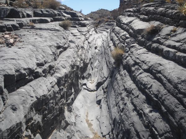
At the high point of the cross-over between the two canyons:
There were a brief set of narrows and polished dry falls as we were dropping down to the other side:
Getting a picture of the guys before they bypassed this dry fall:
Up ahead the side canyon we were in was about to dead end at a massive dry fall. But we found a sheep trail which bypassed it to the right in this picture:
The side canyon we were in ended abruptly up ahead and dropped off into an abyss:
An absolutely fascinating natural cave up on the hillside just prior to the drop off:
After completing the bypass and dropping into the main canyon, this was the view down towards Bighorn Springs:
And this was the full dry fall which we had just bypassed:
Heading further down canyon to get to the bottom of Bighorn Springs:
Abundant greenery was soon evident as I went into Bighorn Springs to do some exploration:
The next three pictures show you some of the greenery of Bighorn Springs and another bighorn skull which I found:
Successfully finding surface water at Bighorn Springs. It didn't look like the best drinking water, but the birds didn't seem to mind drinking from it:
If you look closely in the center of this picture, you can see some of the Bighorn sheep that we spotted:
Patrick was able to zoom in quite well and captured 5 Bighorn sheep in one picture:
After enjoying the sheep for a good amount of time, we pressed on and headed further down canyon:
Looking ahead, you can see the wideness of the canyon which lies between Bighorn Springs and Bighorn Gorge:
The most interesting feature was this absolutely huge 100+ foot dry fall which we passed by, seen in the next two pictures:
A colorful hillside ahead as we approach the major bend in the canyon:
Backpacking towards the head of Bighorn Gorge:
We followed the canyon as it narrowed down, and then took a lunch break at the beginning of Bighorn Gorge. Here we have just started heading down Bighorn Gorge:
I love the bands on these huge towering rock walls in Bighorn Gorge:
Bighorn Gorge is a spectacular canyon. We would have spent a lot more time here, but the summer heat placed a limit on what was reasonable:
Heading down canyon about 15 minutes in from the head:
At about 20 minutes in, we came to the overlook point for the impressive 60 foot dry fall at the beginning of the 1st Narrows:
Steve looking down into the 1st Narrows and the spot where he last stood about two years ago:
This was the view directly down from above. Notice the polished surface of the dry fall:
We did not use the bypass to drop further into the 1st Narrows. In the summer heat, this was not the appropriate time or place, so we headed back out of Bighorn Gorge:
We would have to backpack up a steep rock as we exited the head of Bighorn Gorge:
Patrick backpacking up ahead as the canyon widened out and we began the long hike which had 2,000 feet of elevation gain waiting for us:
We turned off a short time later into O'Brien Canyon. This picture was taken close to the mouth of the canyon:
After surviving the heat of lower O'Brien Canyon, we could see an unexpected set of narrows up ahead:
Dramatic opening look into the narrows of O'Brien Canyon:
Steve at the beginning of the O'Brien Canyon narrows. This portion was a bit reminiscent of Mosaic Canyon:
Looking back out at Kirk as he prepares to enter the narrows. Notice the dramatic contrast between the narrows and the lower canyon:
An overview of some of the lower narrows. In the lower right corner, you can see our group backpacking through:
In the next five pictures, you will see some awesome pictures of the 1st Narrows:
After that the canyon opened up again briefly, but not for long:
In the next four pictures, we backpacked through a 2nd set of narrows. It's kind of hard to divide the narrows of O'Brien Canyon into separate groups, because they pretty much all run together for quite a long time:
This huge chockstone dry fall blocks passage into the 3rd Narrows, which would be the highlight of O'Brien Canyon and our entire trip:
We found a bypass to take us around the chockstone fall (perhaps equal to or slightly more difficult than the Fall Canyon bypass). The next three pictures show the bypass route:
Once we were safely back on the canyon floor, we walked down and overlooked the chockstone dry fall:
The next nine pictures show you O'Brien Canyon's 3rd Narrows in their full glory and beauty:
Steve climbing the dry fall seen in the previous picture. Climbing wouldn't have been so bad without the full size backpacks we were carrying:
The passages were narrow, the walls high, the rock polished and very pretty:
The O'Brien Canyon slickenside can be seen here on the right. Yet another feature which makes this place amazing:
Steve standing in front of the O'Brien Canyon slickenside:
The next thirteen pictures show you what I would call the 4th Narrows of O'Brien Canyon. Notice an abundance of pretty walls, dry falls to climb or bypass, and a steep narrow canyon:
Finally the canyon opened up. Going through the narrows had been so awesome because of the beauty, but also because of the cool shade which provided relief from the hot summer sun:
Check out the interesting designs on this canyon wall we passed by:
Even as the canyon opened up, there were still some small dry falls and obstacles to climb up:
And also some steep areas where we gained elevation quickly:
After the narrows, we hiked in O'Brien Canyon for a while longer, looking for the correct side canyon to turn off into:
Up ahead, we recognized the junction and realized our hike was getting closer to being finished:
Back in the side canyon which leads up to the old spur road:
And finally after two very long hot days, we were back where we had started on White Top Mountain Road:
To finish this special report, we will leave you with three pictures of fossils which we found during our long journey: