MAPS

OVERVIEW
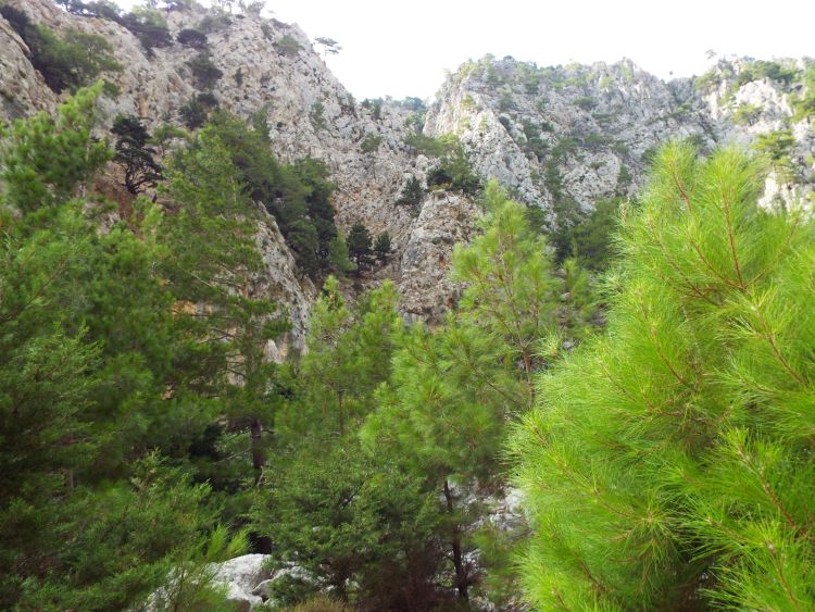
Agia Irini Gorge is a scenic canyon which passes through a beautiful forest and towering walls in the White Mountains of southwestern Crete near Sougia. Difficulties encountered on the hike include finding transportation to and from the canyon and hiking a few steep sections of switchbacks in the middle of the canyon. A Google Earth map of the hiking route (turned to the east for better viewing) can be found by clicking on the button above. GPS coordinates for the parking area at the top are 35° 19.723'N, 23° 50.232'E. GPS coordinates for the parking area at the bottom are 35° 17.130'N, 23° 49.330'E.
OUR VISIT
The day after our successful hike of Sarakina Gorge, we got up early and drove back from Ammoudara to Chania. The drive takes place along the northern coast of Crete and has quite a few beautiful spots to enjoy the scenery. We stopped over in Heraklion for breakfast along the way. Once in Chania, we turned to the south and began climbing up some steep roads into the White Mountains. It was quite an experience driving the narrow roads up and over the pass and down the other side until we finally arrived in the small village of Sougia on the southern coast. Sougia was one of my favorite villages on Crete. It's a very small village which is mostly just a few square blocks of tavernas and accommodations. The locals are friendly and helpful, the food is excellent, the long beach is charming, and the village has a unique feel being at the bottom of the mountains at the end of a long road about 70km from Chania. Once we checked into our hotel, we had to make transportation arrangements for our afternoon hike of Agia Irini Gorge. Agia Irini Gorge is part of what I call "the Big 4" gorges of Crete. The Big 4 gorges include Agia Irini, Samaria, Imbros, and Aradena. I group these four gorges together because based on my research, they seem to be the most well-known and popular gorges on the entire island to hike. And all four are located within the White Mountains in southwestern Crete. Although they appear to be in somewhat close proximity to one another (in air miles), the Big 4 gorges can be challenging to reach and hike during a trip. Hiking them involves using a creative combination of taxis, ferries, and buses to reach starting points and get back from ending points. We found this out as we began our quest to hike all of the Big 4 gorges beginning with Agia Irini (or St. Irene) Gorge. While many Cretans obviously enjoy canyon hiking, one thing they don't seem to be too keen on is doing extra hiking beyond what is absolutely necessary. Thus, while I was used to regularly hiking canyons round-trip at home, while on Crete I made an adjustment and figured out ways to hike all of the Big 4 gorges one-way. With Agia Irini, my plan was to drop off our rental car at the mouth of the gorge (or bottom) and then have a taxi pick us up and drop us off at the head (or top part). Because there were only two taxis operating in Sougia during our visit, we had to hope one would be available to take us. Fortunately, with a slight variation, everything worked out just as we planned. The taxi ride up cost us about 30 euros, which seemed reasonable in view of the driving distance into the mountains.
Once we got dropped off at the beginning of Agia Irini Gorge, we stopped in for a quick drink at the taverna and began hiking downhill into the forest along the well-defined trail. Agia Irini passes through a vibrant forest which includes plane trees, pine trees, Cretan maples, carob trees, cypress trees, oleanders, oak trees, holm oaks, and other trees. The large amount of trees creates an incredibly beautiful setting to hike through. At times, I was reminded a bit of Yosemite back home. The trees also provided a lot of shade which made hiking through the gorge on a hot day a little bit easier. Being that our hike was one-way in the downhill direction and only 4 1/2 miles long, we knew that this would be an easy hike for us. We would be able to take all the time that we wanted to just enjoy the hike while passing through such a beautiful place. One of the ways in which our hike of Agia Irini was different from both Kritsa and Sarakina was the hiking trail itself. Rather than hiking through the wash of the gorge, the trail often kept us above it on one side or the other. Sometimes we gained a fair bit of elevation above the gorge bottom. To me, this had benefits and drawbacks. It did help us to avoid some challenging obstacles and overgrown brush. But at the same time, part of the experience of hiking a gorge is missed if you're not hiking in the wash for extended periods of time. Agia Irini Gorge actually felt more like a wilderness hike than anything else. The hike took us about 4 hours to accomplish and I will explain more details about the hike itself within the captions to my pictures. Throughout the hike, there are kilometer markers to help you keep track of your progress and there are also rest stations with water spigots (which are not always working). We really didn't stop much and passed only a few other hikers being that it was the late afternoon. Also, there are no true slot narrows within the gorge, but the walls do come somewhat close together toward the end of the hike. The hike ends at a taverna, so we took a break at the end to enjoy some pints of Mythos beer while awaiting our ride back to the hotel. In the evening, we enjoyed an excellent dinner in Sougia along the beach overlooking the Libyan Sea. Agia Irini Gorge proved to be a short but outstanding and very beautiful Cretan wilderness hike. Our hike took place on September 2, 2014.
Once we got dropped off at the beginning of Agia Irini Gorge, we stopped in for a quick drink at the taverna and began hiking downhill into the forest along the well-defined trail. Agia Irini passes through a vibrant forest which includes plane trees, pine trees, Cretan maples, carob trees, cypress trees, oleanders, oak trees, holm oaks, and other trees. The large amount of trees creates an incredibly beautiful setting to hike through. At times, I was reminded a bit of Yosemite back home. The trees also provided a lot of shade which made hiking through the gorge on a hot day a little bit easier. Being that our hike was one-way in the downhill direction and only 4 1/2 miles long, we knew that this would be an easy hike for us. We would be able to take all the time that we wanted to just enjoy the hike while passing through such a beautiful place. One of the ways in which our hike of Agia Irini was different from both Kritsa and Sarakina was the hiking trail itself. Rather than hiking through the wash of the gorge, the trail often kept us above it on one side or the other. Sometimes we gained a fair bit of elevation above the gorge bottom. To me, this had benefits and drawbacks. It did help us to avoid some challenging obstacles and overgrown brush. But at the same time, part of the experience of hiking a gorge is missed if you're not hiking in the wash for extended periods of time. Agia Irini Gorge actually felt more like a wilderness hike than anything else. The hike took us about 4 hours to accomplish and I will explain more details about the hike itself within the captions to my pictures. Throughout the hike, there are kilometer markers to help you keep track of your progress and there are also rest stations with water spigots (which are not always working). We really didn't stop much and passed only a few other hikers being that it was the late afternoon. Also, there are no true slot narrows within the gorge, but the walls do come somewhat close together toward the end of the hike. The hike ends at a taverna, so we took a break at the end to enjoy some pints of Mythos beer while awaiting our ride back to the hotel. In the evening, we enjoyed an excellent dinner in Sougia along the beach overlooking the Libyan Sea. Agia Irini Gorge proved to be a short but outstanding and very beautiful Cretan wilderness hike. Our hike took place on September 2, 2014.
SAMPLE PHOTOS


ALL PHOTOS
Many more photographs taken during our visit are available for viewing for this destination. To see all of them, choose one of the two options presented below. The two options are Slideshow viewing and Trip Report viewing. The Slideshow option allows for viewing larger images with an autoplay option and a full screen option (available on most browsers). This option works very well for large computer screens and tablets. The Trip Report option allows for viewing smaller pictures in a standard scroll-down format and enlarging of any panoramic photos taken during our visit. Click on the option of your choice to view all of our photos from this destination. The Slideshow format opens in a new browser window and the Trip Report format uses the same browser window for viewing.
SLIDESHOW FORMAT
TRIP REPORT FORMAT