OVERVIEW
Hiking Gros Morne National Park trails showcases wildlife while visiting pristine ponds, boreal forests, impressive waterfalls, scenic mountain overlook points, and beautiful beach and coastal areas. Difficulties encountered on the hikes include being properly prepared for inclement weather, awareness of current trail conditions, keeping a safe distance from wildlife, and dealing with sometimes slippery and muddy conditions on trails. Route maps and GPS coordinates are not provided because these are official trails which are maintained by Gros Morne National Park. All hikers should obtain complete information on the hikes and current conditions from the Gros Morne National Park Visitor Centre.
OUR VISIT
We spent five days in Gros Morne National Park during our trip to Newfoundland in July of 2019. Prior to arriving in Rocky Harbour (where we stayed during our visit to Gros Morne), we had visited St. John's, Bay Bulls and the Witless Bay Ecological Reserve (for seabirds), Bonavista and Elliston (for puffins), and King's Point (for icebergs). We rented a car one-way so that we could fly into St. John's and fly home from Deer Lake which allowed us to spend more time exploring and less time driving. Gros Morne National Park proved to be the highlight of our trip, as we enjoyed many days hiking together as a family. We ended up doing 9 of the 20 official park trails (as of 2019). These trails included Western Brook Pond, Bakers Brook Falls, Trout River Pond, Coastal Trail, Lobster Cove Head, Southeast Brook Falls, Gros Morne Mountain, The Tablelands, and Green Gardens. The objective of this report is to give you a brief glimpse of most of these trails with the exception of Gros Morne Mountain (which is a separate full report here on this site) and Southeast Brook Falls (which is a very short hike). Be sure to also check out our Newfoundland video report (link here) which showcases our entire trip including our hikes. In addition to hiking, there are other enjoyable activities to do in Gros Morne National Park. There are boat tours to take, historical communities to visit, programs with park guides, places to go swimming, as well as scenic driving tours. And there is extensive wildlife to see such as moose, Woodland caribou, bears, whales, and birds. In fact, there is such a high concentration of moose in the park that they have caused extensive damages to areas of forest. Below, I will share a little bit of information about each of the trails we are sharing photographs of within this report.
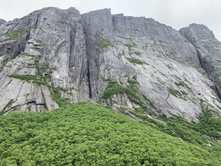
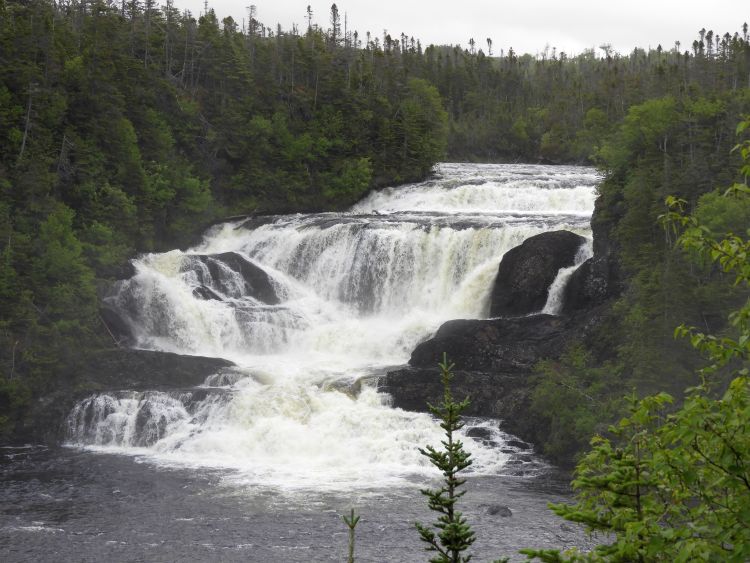
On the morning of Day 1, we did our boat tour of Western Brook Pond. Reservations must be made in advance and it is helpful to arrive early to wait for a seat along one of the sides. A short hike is also necessary in order to reach the boat dock. The Western Brook Pond hike is 1.9 miles each way on the best maintained trail in the park. The towering mountain cliffs above Western Brook Pond (which is a landlocked freshwater fjord that is also the largest lake in the park) can be spotted from the beginning of the hike on clear days. The hiking trail passes through coastal bogs and it can be quite cold when it is windy. One important note is not to do this hike or boat tour on days when it is foggy or cloudy as you will not be able to see the cliffs or waterfalls above the fjord. The boat tour of Western Brook Pond was truly amazing (see Sample Photo #1 below). In the afternoon, we did the Bakers Brook Falls hike as a family, which is 6.2 miles round-trip. This hike introduced us to some of the wildflowers and birds of the park. We passed by a moose and spotted an Arctic three-toed woodpecker. Much of the hike was through a balsam fir forest but there were also some bogs and open areas where we had wide-reaching views all around. At the end, there are three very impressive waterfall overlooks (see Sample Photo #2 below). On Day 2, we hiked about half of the Trout River Pond hike, which is 8.7 miles round-trip. Being that our son Stefan is 7 years old and there were a lot of muddy spots on the trail, we couldn't reasonably do the entire hike. One option that can be done is to arrange for a boat drop-off near the end of the hike and then only hike it one-way. From the parking lot, the trail follows around the left side of Trout River Small Pond (or Outer Pond). It passes through a boreal forest which has ups and downs as it navigates around small stream gullies. There are numerous spots to head down to the shoreline. Later on (past where we stopped), the trail emerges from the forest into a barren area of Tablelands with views of the Narrows and Trout River Big Pond (or Inner Pond). On Day 3, we first visited the Bonne Bay Marine Station for a tour during which Stefan enjoyed the touch tank. Then we did a family hike of the Coastal Trail, which is 3.7 miles round-trip. This was an enjoyable hike that starts out by following Baker's Brook and then turning right and continuing along the rocky shoreline of the gulf. We got to see many shorebirds including Common Terns, Canada Geese, and Northern Gannets plunging into the gulf. There are also areas of unique Tuckamore trees passed by along the way. Later in the day, we drove north outside of the park to check out The Arches Provincial Park. And then we took in the sunset at Lobster Cove Head Lighthouse. On Day 4, I spent most of the day doing a solo hike of Gros Morne Mountain. I have written a separate hiking report which fully documents that entire hike. In the late afternoon, I picked up my family and we hiked out to see The Tablelands. The Tablelands is a unique place where the Earth's mantle has been exposed and you can walk across it. Due to the toxic metal soil, lack of nutrients, and sub-Arctic weather, very few plants and flowers can grow here. We only did the family portion of the hike (2.5 miles round-trip) which stops near the pretty cascades at the Winter House Brook Canyon viewing platform. But if I had more time, I would have done the entire (unmarked) hiking loop as this area was fascinating to check out. The orange-colored peridotite and white-line patterned serpentinite rocks were incredible. On Day 5, we did a family hike of the Green Gardens trail, which is 5.6 miles round-trip. This was our favorite of all the family hikes due to the varied scenery and enjoyable route with good views. The hike first climbs up some (mostly) barren hillsides before crossing a small pass and descending 915 feet in elevation down to the gulf (see Sample Photo #3 below). The beach area was really interesting with sea stacks, tidal pools, and a beautiful hidden waterfall. Doing this hike was a great way to end our trip before our long journey home. Our hikes took place from July 9-13, 2019.
On the morning of Day 1, we did our boat tour of Western Brook Pond. Reservations must be made in advance and it is helpful to arrive early to wait for a seat along one of the sides. A short hike is also necessary in order to reach the boat dock. The Western Brook Pond hike is 1.9 miles each way on the best maintained trail in the park. The towering mountain cliffs above Western Brook Pond (which is a landlocked freshwater fjord that is also the largest lake in the park) can be spotted from the beginning of the hike on clear days. The hiking trail passes through coastal bogs and it can be quite cold when it is windy. One important note is not to do this hike or boat tour on days when it is foggy or cloudy as you will not be able to see the cliffs or waterfalls above the fjord. The boat tour of Western Brook Pond was truly amazing (see Sample Photo #1 below). In the afternoon, we did the Bakers Brook Falls hike as a family, which is 6.2 miles round-trip. This hike introduced us to some of the wildflowers and birds of the park. We passed by a moose and spotted an Arctic three-toed woodpecker. Much of the hike was through a balsam fir forest but there were also some bogs and open areas where we had wide-reaching views all around. At the end, there are three very impressive waterfall overlooks (see Sample Photo #2 below). On Day 2, we hiked about half of the Trout River Pond hike, which is 8.7 miles round-trip. Being that our son Stefan is 7 years old and there were a lot of muddy spots on the trail, we couldn't reasonably do the entire hike. One option that can be done is to arrange for a boat drop-off near the end of the hike and then only hike it one-way. From the parking lot, the trail follows around the left side of Trout River Small Pond (or Outer Pond). It passes through a boreal forest which has ups and downs as it navigates around small stream gullies. There are numerous spots to head down to the shoreline. Later on (past where we stopped), the trail emerges from the forest into a barren area of Tablelands with views of the Narrows and Trout River Big Pond (or Inner Pond). On Day 3, we first visited the Bonne Bay Marine Station for a tour during which Stefan enjoyed the touch tank. Then we did a family hike of the Coastal Trail, which is 3.7 miles round-trip. This was an enjoyable hike that starts out by following Baker's Brook and then turning right and continuing along the rocky shoreline of the gulf. We got to see many shorebirds including Common Terns, Canada Geese, and Northern Gannets plunging into the gulf. There are also areas of unique Tuckamore trees passed by along the way. Later in the day, we drove north outside of the park to check out The Arches Provincial Park. And then we took in the sunset at Lobster Cove Head Lighthouse. On Day 4, I spent most of the day doing a solo hike of Gros Morne Mountain. I have written a separate hiking report which fully documents that entire hike. In the late afternoon, I picked up my family and we hiked out to see The Tablelands. The Tablelands is a unique place where the Earth's mantle has been exposed and you can walk across it. Due to the toxic metal soil, lack of nutrients, and sub-Arctic weather, very few plants and flowers can grow here. We only did the family portion of the hike (2.5 miles round-trip) which stops near the pretty cascades at the Winter House Brook Canyon viewing platform. But if I had more time, I would have done the entire (unmarked) hiking loop as this area was fascinating to check out. The orange-colored peridotite and white-line patterned serpentinite rocks were incredible. On Day 5, we did a family hike of the Green Gardens trail, which is 5.6 miles round-trip. This was our favorite of all the family hikes due to the varied scenery and enjoyable route with good views. The hike first climbs up some (mostly) barren hillsides before crossing a small pass and descending 915 feet in elevation down to the gulf (see Sample Photo #3 below). The beach area was really interesting with sea stacks, tidal pools, and a beautiful hidden waterfall. Doing this hike was a great way to end our trip before our long journey home. Our hikes took place from July 9-13, 2019.
SAMPLE PHOTOS

ALL PHOTOS
Many more photographs taken during our visit are available for viewing for this destination. To see all of them, choose one of the two options presented below. The two options are Slideshow viewing and Trip Report viewing. The Slideshow option allows for viewing larger images with an autoplay option and a full screen option (available on most browsers). This option works very well for large computer screens and tablets. The Trip Report option allows for viewing smaller pictures in a standard scroll-down format and enlarging of any panoramic photos taken during our visit. Click on the option of your choice to view all of our photos from this destination. The Slideshow format opens in a new browser window and the Trip Report format uses the same browser window for viewing.
SLIDESHOW FORMAT
TRIP REPORT FORMAT