


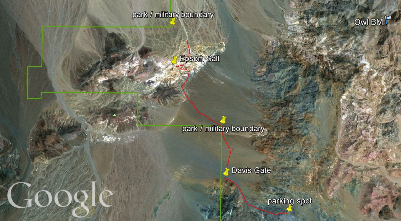
The Epsom Salt Works are located in the midst of the Crystal Hills, which are found in one of the most remote small corners of the park. At the point where the hike begins, you are approximately 40 miles from the nearest pavement. And during my time hiking out in this area, I only saw one other vehicle during a two day period, so you are likely to be alone. If you are unfamiliar with the location of the Epsom Salt Works & Crystal Hills, take out any map you have of Death Valley National Park. Take, for instance, the free Exploring Death Valley map that is given out at the Furnace Creek Visitor's Center. Now look at the southern boundary and follow that boundary all the way to the left (west). You should now see the Quail Mountains labeled below you, a high clearance road to your right (known officially as Owlshead Moutains Road) and Brown Mountain to your left (just outside of the park boundary lines). From this point at the southwestern boundary of the park, go up (north) about one inch and you will see a very small area which extends the park boundary to the left (west) and goes almost 1/2 way to Wingate Pass. It is in this additional area of the park that the Epsom Salt Works can be found. The National Geographic Trails Illustrated map is the only map I have found which actually labels the location of the Epsom Salt Works. Topographical maps identify the fact that these ruins are located within an area known as the Crystal Hills. When hiking out in this section of the park, it's very important to prepare yourself before going and know where you are at all times, in order to avoid accidentally crossing over onto military land and getting into trouble. The Crystal Hills are quite beautiful and this is a very nice area to go hiking, if you can get there. The Crystal Hills can be described as a cross between the scenery found at Artists Palette and Zabriskie Point. And if you'd like to know an inside tip, this area is probably the best place in the park to find a desert tortoise. I came to that conclusion after hiking past an unusually large number of tortoise burrows and also because I found a sign posted by the military. The military is regulating its own travel through the region to the main road in an effort to protect the tortoises which are living there. Below you can see a GE map which shows our hiking route out to visit Epsom Salt Works (click to enlarge map for better viewing). The hike is about 4 miles each way with an elevation loss of about 900 feet.

Road leading from the parking area for Lost Lake to the parking area for the Epsom Salt Works hike:

There is a special parking area set up next to where the road makes a sharp bend to the north to climb up to the defunct Microwave Relay Station:

Looking down from the parking area at the signs clearly showing that this route is for hiking only:
From the parking area, the route follows what appears to be an old but now closed road:


The trail goes steadily downhill and is very easy to follow:

Looking to the north, you can see the meeting of two mountain ranges-- the Panamints (left) and the Owlsheads (right):
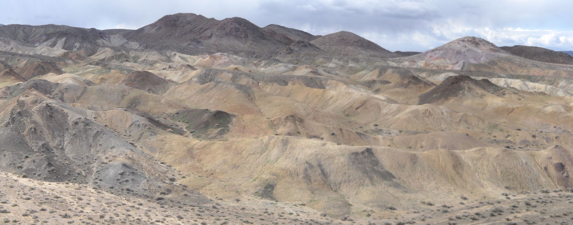
First view of the mysterious Crystal Hills from along the trail:


The first 1/3 of the hike follows this old road directly to the west:

The road dead-ends at the Davis Gate, which is an entry to the military base. Since it is off-limits to Death Valley hikers, at this point you must turn to the north:

Off in the distance Brown Mountain can be seen standing tall at an elevation of 5,125 feet:

The route continues to be easy to follow with no danger of crossing over into military land, as you simply follow the fence line to the north for a while:

After a while, the fence line abruptly ends. This is where staying off of military land can get a bit tricky:

We continued to follow an imaginary fence line up the next hillside, and then turned back to get this photo of the real fence line we had just followed:

From this point on, we just cut a diagonal directly towards the Crystal Hills, which mesmerized us with every step. We were using a GPS to make sure we didn't cross over to where we were not supposed to be:

As we were making the cross-country journey, we passed over this old road which ran to the north and south:

The full beauty and colors of the Crystal Hills now came into view:

The next six pictures were taken of the Crystal Hills from a nice overlook point that we first hiked up to. Notice the great beauty and colorful eroded hills on display. This is a very special area and a worthy destination by itself:
This is a panoramic of the Crystal Hills looking to the west (click to enlarge):


Zooming in on the ruins of the Epsom Salt Works:

Getting a close-up of the pretty purple hill in the background:

Two pictures of Steve with the Crystal Hills in the background:


So why are they called the Crystal Hills? Permit me to share some pictures with you that will answer that question definitively. The next five pictures show large and small crystal-like rocks which literally could be found everywhere on the hillsides:


Look closely at this hillside and you can see hundreds of crystals just resting on the dirt:

Getting a close-up of the hillside and crystals:

Four more crystals which we picked up to photograph, and then returned to the ground:


Old wooden ruins with crystals scattered across the hillside behind:


Main building ruins of the Epsom Salt Works. We know this is the central location because we found a benchmark nearby:

Wooden boards of the roof which obviously caved in a long time ago:

What appears to be an old canteen once used by residents or workers here:

The stone foundation and some of the side framing is still intact:

The rusted out remains of an old car sits in between the two fallen houses:

Looking down the small canyon which winds through the Crystal Hills:
This is the stone foundation of the second structure:


Looking directly in through the former front entrance door:

Notice that the wooden framing of a window is still in place:

More boards on the ground marking something from long ago:

A rusted and burned out old stove unit that was probably once inside of one of the houses:

A giant barrel which likely contained minerals being used in the Epsom operations:

We discovered a natural bridge which was large enough to crawl through:

The next eight pictures show the last remnants of the once glorious Epsom Salt Monorail. All that remains today are the monorail support posts and a few other boards used to help support the tracks:


The next two pictures show a mining shaft which is in the area:


After checking out everything we had time for, we took a bit of a different route back, following an old road which passes directly through the Crystal Hills. This picture is taken looking back:

Soon we came to this sign, which highlights protection efforts for the desert tortoises in the area by the military:

Sure enough there were tortoise burrows everywhere. We just happened to be there when it was a little bit too cold outside for them to come out:

The road merged with the other road we had crossed earlier. At this point we headed due east to stay off of the military land. Once we reached the corner of the fence line, we headed south and retraced our steps to our vehicles:
About 5 minutes after starting the long drive back, we passed by a large herd of burros:


Heading home after a successful hike to the Epsom Salt Works:
