


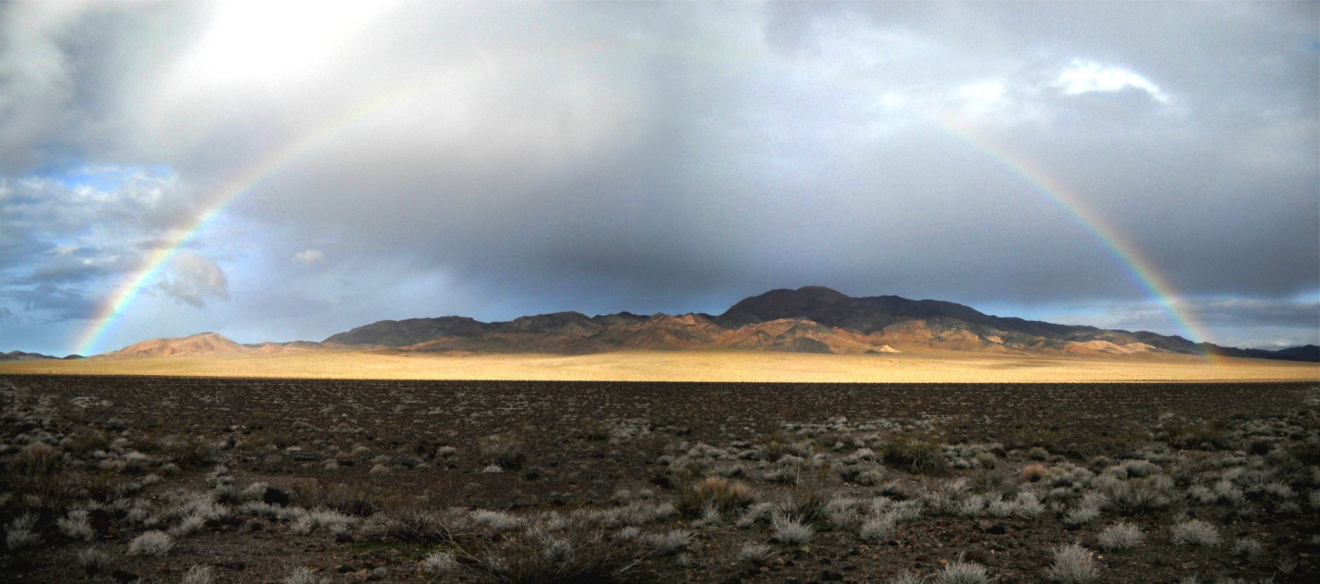
My first-ever hike out to Lost Lake took place the day after I had first visited Owl Lake. Doing both dry lakes on back to back days gave me the opportunity to compare them and the surrounding scenery. The night before hiking out to Lost Lake, I pitched my tent at the trailhead for the hike. The trailhead is the beginning of an old road (now closed) which goes all the way from Owlshead Mountains Road to Lost Lake. Most of the night it rained during my early March 2010 visit, but my tent did an excellent job of keeping all of the water outside. I woke up dry, to warm sunshine and the amazing sight of a full rainbow crossing from one side of the basin to the other. The beautiful rainbow proved to be an enduring companion for the 5 mile hike out to Lost Lake. And following the closed road proved to make the hike very easy and enjoyable. We were able to spend less time worrying about navigating through the terrain, and more time admiring the grand view of the mountains. To the west, we could see the Microwave Relay Station and Owl BM, while to the north we could see Telescope Peak and the Panamint Range. The closed road eventually deposited us at the southern end of Lost Lake. The playa was damp from the rain the night before, but already drying in the warm sunshine and our tracks did not leave any kind of a lasting impression. We hiked a good distance out onto Lost Lake, before turning to the east and hiking up a nearby hillside to get some overlook pictures. Lost Lake was truly majestically beautiful, it's a magical place. Joining me for this hike and the other hikes in the southern Owlsheads was fellow hiker Dave, who is well known in Death Valley for being the person who re-discovered Chuckwalla Canyon Crater after all knowledge of it had been lost. Dave took the panoramic photograph below of the Owlshead rainbow. Click on it to enlarge it for a better view.
Waking up after a wet night to a beautiful view of Lost Lake five miles away:


The appearance of the rainbow definitely lifted my spirits after worrying about the rain all night:
Starting point for the hike to Lost Lake is this old road which has now been closed and converted into a trail. Notice that the rainbow is visible in the upper left corner:


The hike out to Lost Lake looks to be fairly easy just following the tracks of the old road:

Looking over at the defunct Microwave Relay Station:
The rainbow was present for the entire first half of the hike:


Just ahead is the first small hillside which sticks out into the basin and divides the hike in half:
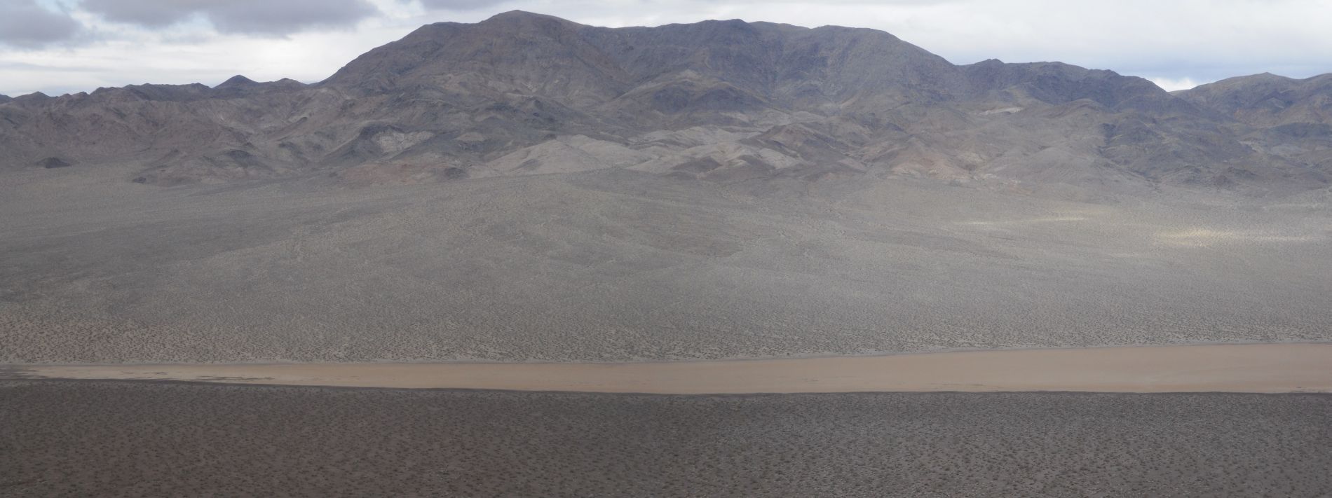
Looking out towards where Lost Lake should be, but it wasn't visible. We couldn't see it for most of the hike:


The old road wrapped around the hillside to the west and continued:

Looking over at Owl BM as we were walking directly across from the summit:
Again the old road is clearly visible and we could spend less time thinking and more time enjoying:


The clouds lifted from the Panamint Mountains off in the distance for a few short minutes:

So I zoomed in on Telescope Peak. This view of Telescope reminded me of the time the clouds lifted from Mt. McKinley when I was camping at Wonder Lake in Denali National Park:
Final stretch across some easy terrain before reaching Lost Lake:


This is the shoreline of Lost Lake. The shoreline all around the lake contained darker rocks and a few puddles of water:

On Lost Lake now and enjoying the view west towards the Microwave Relay Station and Owl BM:

Getting a close-up of Owl BM, which is definitely on my future hiking list:

The view north all the way across to the other end of Lost Lake:
Zooming in closer only to find that the clouds have returned and are once again covering the Panamint Mountains:


Two close-up shots of the slightly wet and cracked mud of the Lost Lake playa. My original plan was to backpack out here and camp on the playa overnight. I'm sure glad that I dropped that idea:


View towards the east. In a little while, we would be hiking halfway up the ridge in the distance to get some nice views of Lost Lake:

Two pictures of Steve on his memorable visit to Lost Lake:

Dropping the camera closer to the ground for a photograph looking across the lake:


Lost Lake is an extremely scenic and special place to spend a day:

Death Valley legend Dave out on the playa:

The next three pictures show you views of the eastern shoreline of Lost Lake. Notice the contrast between the tan or brown playa and the black shoreline:


View of Lost Lake as we began hiking up towards the hillside:
The next three pictures are a 3 shot panoramic of Lost Lake looking south to north:


Up on the hillside now after hiking for a solid 30 minutes uphill:
Mostly complete view of Lost Lake from this high overlook:

And now we have a panoramic of the southern half of Lost Lake and the mountains containing Owl BM (click to enlarge):

Looking at the northern end of Lost Lake in the next two pictures:


Two pictures of Steve with Lost Lake in the background:


One final view showing the sun shining on Lost Lake as we prepared for the 5 mile return hike:
