


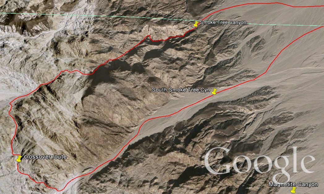
Smoke Tree Canyon is one of my favorite canyons in the Owlshead Mountains. It is the next major canyon south of Through Canyon. All of the canyons south of Through Canyon are officially unnamed (with the exception of Sagenite Canyon), as they were mostly explored until the last couple of years. This is probably because of the size of Death Valley National Park and the isolation and lack of information available about the Owlshead Mountains. However, myself and a few others have been working our way through many of these canyons and have made some interesting finds. Smoke Tree Canyon was one of these great discoveries. If you read my Trip Report for Through Canyon, then you probably remember that I said Through Canyon was once famous for the smoke trees in the canyon. In fact, I remember reading the park's official web site a few years ago and they said Smoke Tree Canyon contained "the only stand of smoke trees in the park", thus reflecting the knowledge of the time. That has since been changed with the discovery of Smoke Tree Canyon, which combined with South Smoke Tree Canyon, contains literally hundreds or thousands of smoke trees. They are everywhere, as you will see in my pictures down below. To start with, I have a Google Earth map which shows the location of Smoke Tree Canyon, the cross-over route which we took into South Smoke Tree Canyon, and the long distance from the Harry Wade Road (approximately 4 miles of hiking to reach the mouth). The interesting thing about South Smoke Tree Canyon is that it actually contains more smoke trees than Smoke Tree Canyon. However, the canyon itself is not as pretty, as it is extremely wide. This report combines the canyons of Smoke Tree Canyon and South Smoke Tree Canyon into one report. (Note-- click on the GE route map below for a close-up of the actual canyons loop).


Parking on the Harry Wade Road. I forgot to write it down, but I believe I was about 10 miles south of the Badwater Road. Basically, the key is to park due east of the Smoke Tree Canyon mouth:
The mountain in the middle divides the two canyons. That's Smoke Tree Canyon to the right and the wider South Smoke Tree Canyon to the left:
Looking over at the Confidence Hills while hiking across the easy hard and soft mud terrain:
Crossing the Amargosa River bed is the only slightly tricky part:
After a couple of easy miles, the hike begins climbing uphill towards the mouth of Smoke Tree Canyon:
At the mouth of Smoke Tree Canyon looking back across the vast desert terrain we have been crossing. This is a long journey. My sister wanted me to take this picture to show her friends at college how far she had hiked:
As expected, a smoke tree was there to greet us upon our arrival:
Looking up into the canyon from the mouth:
An interesting red boulder sitting atop the canyon wall at the beginning:
Looking up the canyon wall once again near the entrance:
I always love walking past a massive boulder of decomposing granite:
You are going to be seeing a lot of smoke trees in this Trip Report, so you may as well get used to it:
Just before we entered the long narrows (2-3 miles long) of Smoke Tree Canyon, this picture was taken looking back out the canyon mouth:
Smoke trees grew everywhere in the canyon, on both sides close to the walls and in the middle:
My sister Tiffany heading up canyon. This was her first hike in the Owlshead Mountains:
As you can see, the canyon narrows considerably and is extremely interesting from the start:
Small caves and interesting formations up on the canyon wall:
Passing by a multi-colored rock wall in the canyon:
The same terrain on the canyon floor as I've become accustomed to in the Owlsheads. Very easy to walk on and solid ground:
The rocks of the Owlsheads have fascinating shapes to them:
Continuing up the narrows with a smoke tree in the distance:
Steve standing at this location. Note the rock designs on both sides of the canyon walls:
More pretty rock designs in the next two pictures:
There were a variety of smoke trees in the canyon, as some of them were tall, some short, some green, some dead-looking, and some mangled:
In the next two pictures we are passing through some very narrow sections of canyon:
Looking up at some tall peaks in the next two pictures:
Smoke trees sitting in the canyon wash are visible in the next four pictures. Can you spot all of them?:
This is one cool looking mountainside. There is so much beauty here:
Two more pictures of smoke trees while heading up canyon:
A lot of times we felt dwarfed as we were hiking past monolith rocks:
Tiffany and Steve standing by a very tall smoke tree:
The next four pictures show more smoke trees in the canyon:
Check out this unique looking formation of rocks reaching out like pillars into the sky:
Tiffany hiking past more of these unique rock formations:
Once again, four more pictures of different looking smoke trees:
Lots of huge boulders sitting on the canyon floor:
At this point, we were deep into Smoke Tree Canyon. These next four pictures of smoke trees were taken as we had progressed about 4/5 of the way through to our goal:
I heard my sister scream down canyon, so I climbed up to this vantage point and looked back down towards the mouth. It turns out she screamed because a tarantula had walked across her path:
From the same vantage point looking further up canyon. This picture and the last one give you a good perspective of what it looks like here:
Steve standing next to his favorite smoke tree in Smoke Tree Canyon:
Finally the narrow canyon emerged into this wide open space where we could see ahead for a good mile:
We stopped for lunch and then continued heading up canyon until this point, where we began our cross-over into South Smoke Tree Canyon:


This is the view from Smoke Tree Canyon looking up the side canyon to the south. We weren't exactly sure where the perfect cross-over route was, but this looked like it would work:
So we turned off and began working our way up through the narrow wash towards the pass:
Not much further now until the pass, which is just ahead:
Looking back at Tiffany making her way up the side canyon to the pass:
Now standing at the pass and looking down the other side. What a grand view:
A picture of Steve in the midst of the Owlshead Mountains:
Tiffany began working her way down the other side of the pass while I was taking in the view:
After a short time we dropped into a wash with easy ground to walk on:
And smoke trees actually started appearing in this side canyon fairly regularly:
Looking back up towards the pass (low ridge point in the top part of the picture):
It was quite fun hiking down this side canyon. There were very few obstacles, with the exception of some easy bouldering:
First view down into South Smoke Tree Canyon. We were actually stunned when we saw this. We had heard there were more smoke trees in South Smoke Tree Canyon, but we could see that they were literally everywhere up ahead:
Dropping into South Smoke Tree Canyon and looking back up the side canyon we were just in:
And the view looking down South Smoke Tree Canyon:
Smoke trees are visible in the next nine pictures. There was a heavy concentration of them for quite some time in the canyon. I'm going to be quiet for a few minutes, but as you look at the smoke trees, also check out the canyon walls and rocks up on the mountainsides of South Smoke Tree Canyon:
The canyon got extremely wide as came closer to the mouth. Also, the smoke trees disappeared for a short time:
A picture of Tiffany and Steve while looking back up the very wide South Smoke Tree Canyon:
Two more pictures as we reached the canyon mouth and began our long hike back across the open desert:
On the way back to our truck, we found several shells resting on the ground: