


Through Canyon is the most well known canyon in the Owlshead Mountains. It is marked on nearly every map of Death Valley and has even been written up as a recommended hike in a few guidebooks. Yet, I get the feeling that it probably receives very little visitation. I can think of several reasons for this. First of all, it is a long distance away from Furnace Creek (over one hour) and involves about 7 miles or so of driving on a gravel road. Second, to reach the mouth of Through Canyon requires a hike of 4.3 miles. That's longer than most people will spend hiking through an entire canyon, so it's unlikely they would hike the extra just to reach the starting point. But I must say that I feel Through Canyon is an excellent canyon to start with if you are new to the Owlshead Mountains. It gives you some grand views of the decomposing granite making up the range and introduces you to another world. You see, when you are hiking in the Owlshead Mountains, you don't feel like you are hiking in Death Valley, because everything is so different and unique. I should say at this point that I would probably divide the canyons of the Owlsheads into two regions. The canyons starting with Through and continuing north and the canyons south of Through Canyon. The northern canyons (including Through, Granite, Contact, Owlshead, Talc, Slickenside, and Wingate) are mostly wide and filled with open space. Meanwhile, the southern canyons (including Smoke Tree, South Smoke Tree, Magnetite, Passage, Sand, Quartz, South Quartz, Drone, and Sagenite) are mostly narrow and put you up close and personal with the decomposing granite walls and boulders. However, although the southern canyons are clearly more interesting, information on them is very hard to come by. Outside of my site, practically nothing is published on them.
But getting back to Through Canyon, you might be interested to learn about the origin of the canyon name. A friend of mine who is a park ranger revealed to me that Through Canyon is so-named because it goes through... to the other side of the Owlshead range. And the other side of the range is mostly a wide open plateau where you can easily see for 20+ miles in many different directions. As you will see in my pictures, I hiked Through Canyon all the way through to the other side, and what a spectacular, grand view I was rewarded with! Words cannot express how special it was to catch the first glimpse in my life of Owl Lake far off in the distance by hiking to this special vantage point. This is what makes Through Canyon so special. But to see it adds on an extra 3 miles to an already long hike of 15 miles round-trip (if you're looping back down via Granite Canyon as I did). After you read my report, be sure and continue the hike with me by clicking on the Trip Report for Granite Canyon. (Note-- click on the Google Earth maps below to enlarge them).
But getting back to Through Canyon, you might be interested to learn about the origin of the canyon name. A friend of mine who is a park ranger revealed to me that Through Canyon is so-named because it goes through... to the other side of the Owlshead range. And the other side of the range is mostly a wide open plateau where you can easily see for 20+ miles in many different directions. As you will see in my pictures, I hiked Through Canyon all the way through to the other side, and what a spectacular, grand view I was rewarded with! Words cannot express how special it was to catch the first glimpse in my life of Owl Lake far off in the distance by hiking to this special vantage point. This is what makes Through Canyon so special. But to see it adds on an extra 3 miles to an already long hike of 15 miles round-trip (if you're looping back down via Granite Canyon as I did). After you read my report, be sure and continue the hike with me by clicking on the Trip Report for Granite Canyon. (Note-- click on the Google Earth maps below to enlarge them).
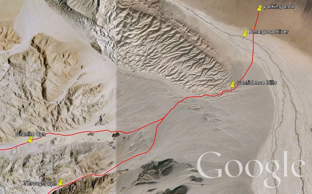

The starting point for the hike to Through Canyon (and Granite Canyon) is on the Harry Wade Road about 7 miles south of Badwater Road. You are basically parking near the old Confidence Mill site. Start hiking towards the left side of the Confidence Hills as seen in this first picture:

Along the way, you will cross the (hopefully) dry Amargosa River:

Try to work your way around the Confidence Hills without getting too caught up in trying to shortcut it through them:

Looking back towards the Harry Wade Road, you can see my white truck far in the distance:

I am now crossing the Confidence Hills but continuing to stay to the left to avoid too many ups and downs:

If you go far enough left (which is south) you will drop into this huge wash which cuts right through the southern end of the Confidence Hills. Reaching this wash is the secret to having an easier hike early on:

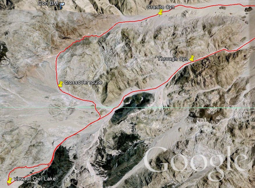
In this picture, Through Canyon is the dark area to the left, while Granite Canyon is the wide area to the right. It is best to hike up Through Canyon first, if you are planning on looping them:

Getting closer to the mouth of Through Canyon after what feels like an eternity of hiking over the easy terrain:

And now I have arrived. Getting ready to enter Through Canyon after a couple of years of researching and learning about it:

At the mouth of Through Canyon a smoke tree was waiting to greet me:

This is the view looking up Through Canyon near the entrance:

As you can see, the decomposing granite walls rise high up right from the start:

Steve pausing for a picture before continuing up Through Canyon on a solo hike:

There are a good number of smoke trees in Through Canyon. In fact, Through Canyon was once famous for its smoke trees. To see why that is no longer the case, visit my Trip Report for Smoke Tree Canyon:

Most of the scenery here is on the grand scale, as Through Canyon is consistently wide:

This is probably the narrowest it gets until near the head of the canyon where it ends:

The smoke trees definitely liven up the canyon and increase the enjoyment of hiking here:

Heading into the mid canyon now, the scenery is constantly changing:

Here is a pretty smoke tree growing next to the low canyon wall:

The walls were sometimes low, but just beyond the mountains would tower up stacked with boulders:

This is one example of what I am talking about and typical scenery in the Owlshead Mountains:

Zooming in on some of the colorful boulders up on the mountainside:

This massive boulder was resting in the wash in the middle of the canyon:

And here is another massive boulder looking like it could roll over the edge and into the wash at any time:

Even when I would get distracted looking up the sides of the canyon, another smoke tree would always catch my attention:

The picture of Steve is taken while looking back down the canyon:

Passing an interesting area of small hills to the right. If you're looking for Granite Canyon, don't get fooled into turning off here, because this is not the route:

The canyon actually gets extremely wide at this point and there is a lot to see and check out. But to continue up canyon, stay to the right of the black hills ahead:

Passing by the black hills. If you take a look at the ground, it is notable that the terrain of the Owlsheads almost never changes. It is firm, solid ground and easy to walk on:

Looking up at some more towering peaks in Through Canyon:

This rock outcropping was in the middle of the wash heading up canyon. I stopped here to eat my lunch and take a nice break. This picture was taken looking back down canyon after I had finished and was continuing my hike:

A streak of red infiltrating the black hills I was passing:

At this point the canyon opens up wide ahead once again. And the route to Granite Canyon turns to the right, following the base of the mountainside:

However, I stopped here and pulled out my 7.5 minute Confidence Hills West topographical map (which I had purchased in the Furnace Creek Visitor's Center the day before). I was trying to find the correct route to stay in the main canyon and reach the end where it went through to the other side:

I found the correct route which just kept going straight up the canyon. At this point, somebody heading for the Granite Canyon loop would have already turned northwest and be heading in a different direction:

As I got closer to the head of Through Canyon, the walls finally got smaller and narrowed down quite a bit:

And a tarantula walking across the wash startled me:

Towards the end here was also where I started regularly seeing tortoise burrows. For some reason the desert tortoises must like this part of the canyon:

Just up ahead the canyon reaches the head and ends. Soon, I climbed up the left side of the canyon:

And this was my view as I had made it all the way through Through Canyon:

Looking southwest, Owl Lake is visible (barely) towards the middle of the picture. Those are the Quail Mountains off in the distance:

Looking west from the divide of the Owlshead Mountains:

And looking northwest from this very unique viewpoint:

Steve getting his picture with Owl Lake and the Quail Mountains in the background. I would have loved to hike down to Owl Lake and check it out, but it would have turned an 18 mile hike into a 28 mile hike. That's not possible in one day:

After admiring the grand view, I headed all the way back down to the place where I was studying the map. That was a 3 mile detour, but well worth it as it was the highlight of the day. Now I am continuing around towards the head of Granite Canyon:

The final three pictures show you the view as I wrapped around the mountainside and made my way over to Granite Canyon. To continue the journey with me, go to my Trip Report for Granite Canyon:


