


Chuckwalla Canyon Crater is a destination in Death Valley which has been unknown for the past few decades. Yet, the crater appears to be rich in history and perhaps heavy in visitation by park tourists at one time. Its rediscovery took place in early 2009, when a Death Valley regular named Dave was studying Google Earth maps of the eastern side of the Panamint Range. Suddenly, a small circular area on the map caught his attention in Chuckwalla Canyon, as he noted its similarity to the well known Panamint Valley Crater as seen on Google Earth. On his next trip to Death Valley, Dave hiked out into Chuckwalla Canyon, and sure enough he found out that the Panamint Valley Crater had a twin. Almost 11 months later, I had my first chance to hike out and see the Chuckwalla Canyon Crater for myself, and I found it to be extremely fascinating. This is not only because the crater is unique and interesting to look at, but because as I mentioned eariler, the crater appears to be rich in history. To reach the crater, I drove up Hanaupah Canyon Road to about the 1,000 foot level and parked off to the side. I then hiked northwest cross-country towards the right side of a hillside (shown in a picture down below marked with a red arrow). Eventually, I ran into a well established trail leading around the hillside, which dropped me into the wash of Chuckwalla Canyon. The trail disappeared for a while at this point. But after I had crossed the wash and reached the sloping hill where Chuckwalla Canyon Crater is located, I once again found a very well established trail. This clearly was not a trail made by bighorn sheep or burros, but a trail that had been heavily used by people at one time. The trail continued all the way to the rim of the crater, down into the crater, and all the way around the rim of the crater. My thinking on finding this trail was that perhaps 40-50 years ago or more, Chuckwalla Canyon Crater was an established and well known tourist destination for visitors to Death Valley. But somehow, through the passage of time and the passing of a generation, knowledge of the crater was forgotten and it was no longer visited. Adding weight to my theory is something that a park ranger told me-- that there was once an actual road leading up to Chuckwalla Canyon. Whatever the case, I am happy to share with you some of my pictures taken during my visit to Chuckwalla Canyon Crater in November of 2009.


The Chuckwalla Canyon Crater as seen on Google Earth (middle of picture). If you're searching for it, the crater is relatively close to the mouth of the canyon up on a small hillside:
Parking on the Hanaupah Canyon Road. The road was quite rough for the short distance that I drove it, with one very difficult area to get past with only 2wd and high clearance:
The red arrow shows you the direction I was hiking towards. Basically, I was hiking cross-country from Hanaupah Canyon Road to the mouth of Chuckwalla Canyon. From where I parked, the hike was about 2.5 to 3 miles each way to the crater:
Along the way, there were some amazing wind and sand sculpted rocks sitting out in the middle of nowhere:
This rock in particular stood out for its unique appearance:
Steve finding a nice place to rest along the way to Chuckwalla Canyon:
Two more pictures of interesting rocks in the same vicinity:
In front of me now stood the hillside which I needed to work my way around in order to reach Chuckwalla Canyon. But first I would have to drop down to the bottom of the hill:
A nice view of Telescope Peak was visible along the route:
Once you have dropped down to the bottom of the hill, a clear trail becomes evident:
This old trail leads directly up towards the mouth of Chuckwalla Canyon. A very convenient find after hiking over some rough terrain for the past 45 minutes:
Following the trail through the last portion around the hillside:
Arriving in the wide wash of Chuckwalla Canyon at the mouth. This view is looking up canyon:
And not far from the canyon mouth, these small hills (bottom of picture) sit to the northwest. The base of the hills are about 10-15 minutes from the canyon mouth. In this picture, the key is to aim for the left hill, which is where the established trail continues up to the crater:
Looking up Chuckwalla Canyon, the canyon appears to narrow considerably up ahead. Unfortunately, I was pressed for time on this hike so I couldn't explore the actual canyon any further. Far in the distance, Wildrose Peak can be seen, which drops down into Death Valley Canyon, the next canyon north of Chuckwalla:
Once you have reached the hills, this is the view looking back down the established trail towards the canyon mouth:
It's certainly an exciting moment to catch sight of the little known Chuckwalla Canyon Crater for the first time:
Getting closer to the destination. It becomes clear that yes, indeed, this is a crater:
The trail continues all the way to the edge of the crater and wraps around it:
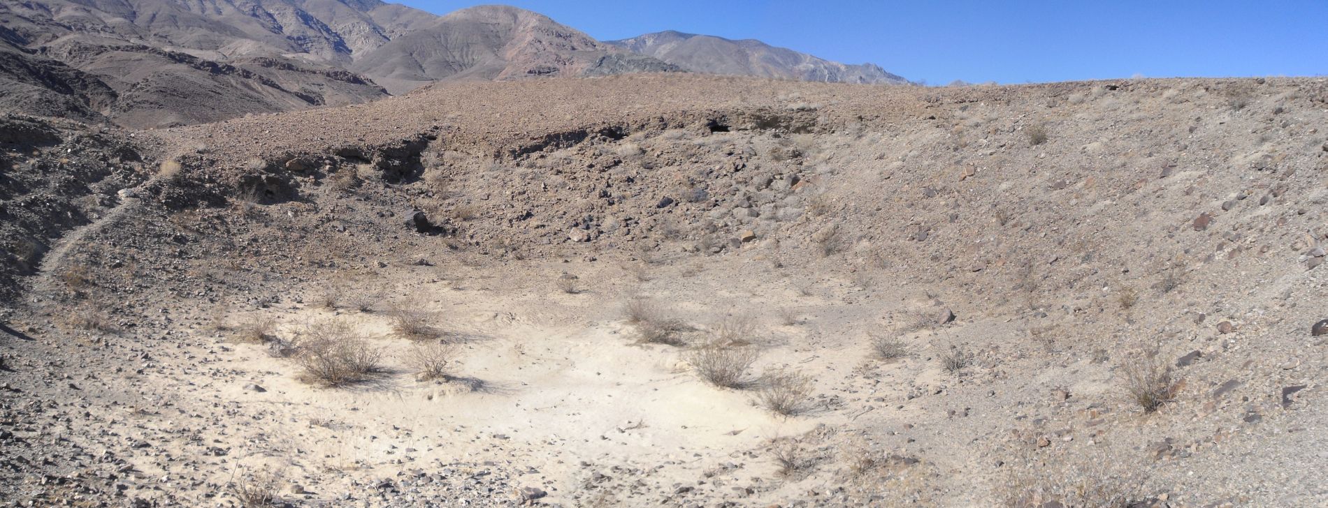
This is a panoramic view of the entire crater looking west from the first viewpoint (click to enlarge):
This picture of Steve down in the bottom of the crater shows you the size of it:
Dropping down into the crater now and showing the view towards the west:
View from inside the crater looking south. You can see how well defined the trail is which climbs out of the crater:
The view looking east from inside the crater:
View looking north from inside the crater. As you can see, the northern wall of the crater is the steepest and highest:
Time for a walk around the crater now to get some more views in the next five pictures:
In this picture, you can see the clearly defined trail which circles around the crater:
One more picture of Steve in the bottom of the crater:
A few final pictures of the Chuckwalla Canyon Crater before beginning the hike back to the truck:
View of the Badwater Basin from the rim of the crater looking east:
An awesome panoramic of Chuckwalla Canyon Crater showing the shape and depth (click to enlarge):