


TRIP REPORT PHOTOS
Upon driving into Opunohu Valley, this is the view to the south. Visible are Mount Tohivea (left peak in the clouds), Three Coconuts Pass (just to the right of the low spot on ridge), and Mount Mouaroa (right peak):

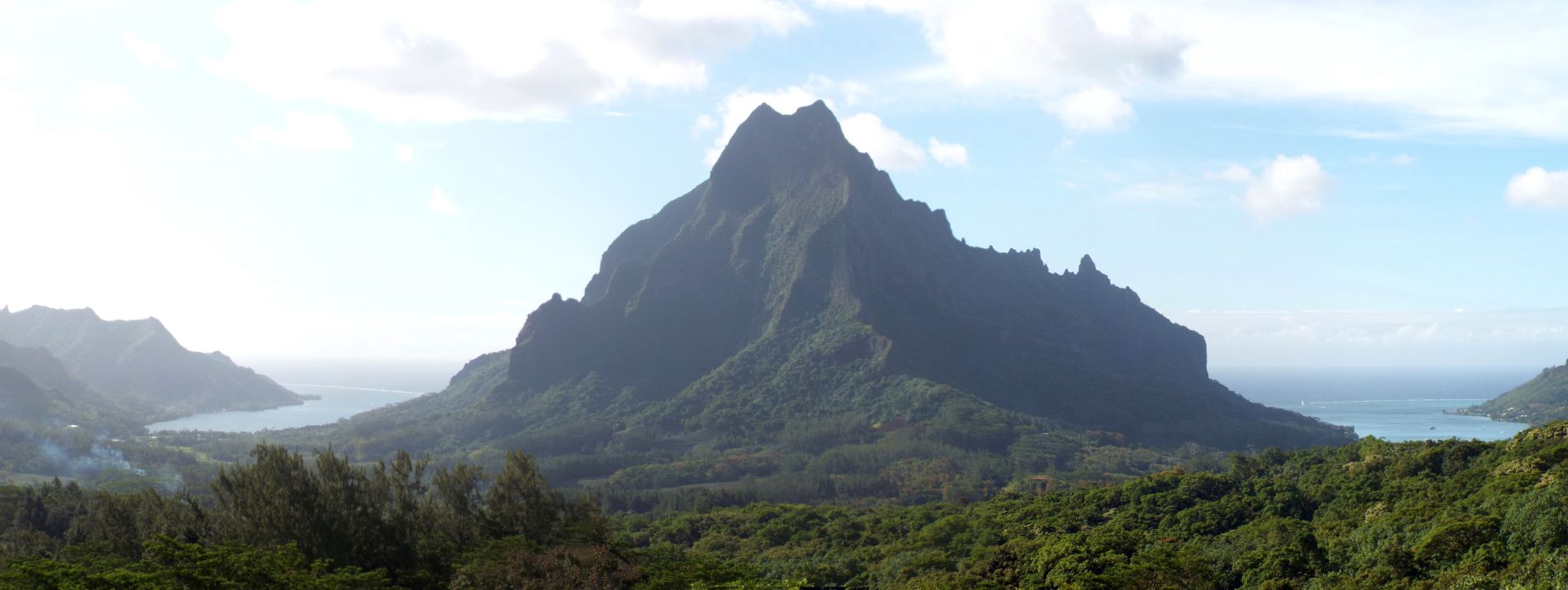
Mount Mouaroa towers above Opunohu Valley at 2,887 feet in elevation:

Check out this unusual saddle on the ridgeline with a vertical cliff preventing attempts to walk along the ridge in this area:

Three Coconuts Pass is the middle option on this hiking sign at the Belvedere. Note the trail marker color and also the expected hiking time of 3 hours:

Panoramic view from the Belvedere overlooking Opunohu Valley (click to enlarge):
Mount Rotui (2,949 feet) is a dramatic peak which divides Opunohu Bay and Cook's Bay:

From the parking lot, these towering cliffs are directly behind you:

Mount Tohivea, the highest peak on Moorea at 3,960 feet in elevation, was currently obscured by the clouds:

Taking another look at the strange-looking saddle we had seen earlier. We were not heading toward this saddle, though:

Starting on the Three Coconuts Trail, which cuts a path through jungle greenery:


Tahitian chestnut (or mape) trees were widespread throughout the entire trail:

Tahitian chestnut trees can grow up to 66 feet in height with a crown diameter of 13 to 20 feet:

They can also grow up to 6.6 feet per year and yield up to 165 pounds of fruit each year once a tree has aged 25 years:

But obviously, it is the alien-shaped trunks, buttresses, and root systems of these trees which makes them stand out:

Reaching our first stream crossing, which had a minimal amount of water flow:
We were following the blue trail markers, which meant that the trail turned left here:


Catching sight of a Banyan tree up ahead through the thick brush:
Trying to capture a Banyan tree, with its aerial prop roots so widely spread out, in a single picture can be quite challenging:


The buttresses of the Tahitian chestnut were in past times used for communication. The Maohi people (ancient Polynesians) would hit these hollow buttresses with a stick to communicate with others in nearby valleys:

Indeed, we tried knocking on the buttresses with our hands and they did make an unusual noise and sound hollow inside:

It is said that the buttresses of the Tahitian chestnut can grow up to 10 feet high and 6 feet wide. And animals such as wild pigs are said to take refuge behind them:

The landscape was covered with Tahitian chestnuts. It was hard to stop taking pictures of them because the bottom of every tree is unique:
Wild vines and erratic branches growing in all directions and forming a wall in the jungle:


Sunlight filtering into the jungle (or tropical rainforest) through the vines and trees:

Twin Tahitian chestnuts both with interesting designs:
A cave-like area of jungle trunks, branches, and vines which we passed by:

Josh seen on the trail as it wrapped around the side of these tangled branches:


Charlie looking up at the Tahitian chestnut canopy after another stream crossing:
As you can see, the canopy was quite impressive way up above us:


We were surprised when the trail abruptly passed through a bamboo forest:

The bamboo culms were thick and towered high into the sky:
Looking up toward the bamboo leaves high above us:

The leaves of ferns and other native plants were quite large in size:

I'm fairly sure that this multi-colored leaf has fallen off of a Tahitian chestnut tree:

Turn-off for the switchbacks portion of the Three Coconuts Pass trail:

A sudden break in the trees and brush allowed for far-reaching views of Opunohu Valley:

Mount Rotui was the dominant feature visible on the landscape:

These sheer cliffs located across the lush valley also stood out:

Extensive tree growth once again took over and limited the great views:

Catching sight of some African tulip trees as we neared the back of the valley:

African tulips have orange-red flowers which appear in beautiful blooms up in the air above the foliage. The flowers are usually out of reach and can only be photographed from below:


The trail got much narrower and partially overgrown as we continued on:
Check out the interesting curves of the branches visible in the next two pictures:


More African tulip trees, sometimes referred to as the "king of flowering trees":

Notice how African tulip flowers point upwards and they have a unique bell shape to them. The flower buds contain water sealed inside of them which squirts out when opened:

Mount Rotui making another appearance high above the tallest branches:

Typical section of switchbacks going back and forth steeply up the mountain:


Josh climbing the switchbacks portion of the hike as we neared the top:
Arriving at Three Coconuts Pass (1,171 feet in elevation):

Looking out from the exact location of the pass, the views are not that great:

It is necessary to continue a little bit farther along the ridgeline in order to reach the first of two outstanding viewpoints:

The trail along the ridge becomes even more narrow but the path is still clearly visible:

The trail skirts to the left (south) as it bypasses a section of the ridge:

Reaching the first of two viewpoints. This first one can be considered the Three Coconuts Pass viewpoint:

These two majestic peaks stand out. The left peak is actually much higher than the right one:

The left peak is Mount Tohivea, the highest point on Moorea. Earlier, it was obscured by clouds. But those have lifted and we now had a perfect view:

The right peak looks quite impressive as well from this vantage point:

This was our first view looking down a valley to the south on the other side of the ridge:

Zooming in to the south, the village of Vaianae, the lagoon, and the reef are all visible:


Beyond the first viewpoint, the trail continues steeply uphill, once again skirting the south side of the ridge:
Eventually, the second viewpoint is reached. This is the key spot to reach if you want to make the most of the hike and have the best views. The 419 meters sign marks the spot:

Looking straight down over the cliffs at the top edge of the valley. You can see why caution is in order around this area:

In the next three pictures, notice how we now had unobstructed views of Opunohu Valley:


Looking straight down the ridgeline we had partially skirted around toward distant peaks:
View to the east showing the valley on the opposite side of the ridge:

The two majestic peaks visible from the earlier viewpoint were also prominent from this lookout spot:

The right side peak is closer to our location so it really stands out:

But being that Mount Tohivea is the highest point, it is even more impressive. We were grateful to have a view of the summit with no clouds covering it:

To the left of Mount Tohivea are these minor peaks and sheer cliff face which also towers over the valley:

Notice that there is another low saddle visible far in the distance across the valley to the east:

Above the saddle sits the sharp summit of Mount Mouaputa at 2,723 feet. Mouaputa means shark tooth and when viewed from other angles on Moorea, a hole is visible through the mountain near the top:

These rugged cliffs south of the village of Maharepa are visible across the valley to the northeast:

Cook's Bay (named for Captain James Cook who anchored in nearby Opunohu Bay) is visible here:

Mount Rotui is seen front and center looking to the north. The distinct ridgelines coming down the mountain remind me of the buttresses of the Tahitian chestnut tree:

Charlie pictured with Mount Tohivea in the background:

Getting a picture with Mount Rotui in the background:

To the left of Mount Rotui is Opunohu Bay:


Perhaps the most dramatic peak in the area is Mount Mouaroa, which towers up into the sky a short distance to the west:
This is the view looking to the south, which once again shows the valley leading down to Vaianae:

Taking a closer look at Mount Mouaroa (2,887 feet) which was quite close to the viewpoint we were standing on:


The trail eventually peters out and you can't really approach the base of Mount Mouaroa. This great view will have to suffice:
One more zoomed look at Mount Rotui:

Opunohu Valley holds some remarkable trails and scenery:

Fully zoomed view of the peak to the east which was in close proximity to us:

And a fully zoomed summit view of Mount Tohivea, the island's highest point:

Heading back down through the bamboo forest as daylight fades:

