


TRIP REPORT PHOTOS

Once it was light enough to see and take pictures, the scenery impressed right from the start:

Birds kept me company the entire day. This is a female White-rumped Shama:

The Kalalau Trail spends a lot of time winding into and out of small valleys:

When the trail is not inside valleys, it is usually on cliffs just above the ocean:

A beautiful January 2014 morning in Kauai with mostly clear skies:

One of the biggest differences with mainland hiking was the presence of tropical trees, many of which I had not seen before. The next three pictures give examples of this:


At this spot, the brush from the trees was so thick that it created a tunnel to pass through:

Na Pali literally means "the cliffs" and well describes this area:

Arriving at Hanakapiai Stream crossing, which is 2 miles into the hike:

I spotted a Black-crowned Night Heron sitting on a rock near the stream:

I crossed the stream right at the path and the water was just above my knees. Any higher, and I would not have been able to cross until later:

Winter conditions at Hanakapiai Beach meant no sand and rough water:

Looking out at the waves breaking close to Hanakapiai Beach:

This sea cave was completely inaccessible as the water crashed against the rocks and flooded the tunnel:

The hiking trail continues steeply uphill beyond Hanakapiai Beach:

The trail eventually circles around to a viewpoint of the beach area below:

There were also good views back across to the other side of Hanakapiai Valley:

The ridgeline along the top of the mountains was filled with jagged peaks:

View of one of the many switchbacks heading up the longest continuous uphill section of the trail:

The trail works its way to the base of this rock wall, which can be seen from far below at the beach:

Zooming in on some clouds forming over the Pacific off the coast:

The trail continues to follow the base of some rocky cliffs:

A beautifully shaped cliff high above the trail:

The trail headed directly for this small pretty waterfall:

Notice how the trail crosses right below the cascading water. On the hike back in the dark, there were lots of large Cane Toads hanging out in this area:

After passing through The Gate (the high point of the trail), there was an immediate view of the gorgeous Hoolulu Valley:

Steve with Hoolulu Valley in the background. This was one of my favorite viewpoints along the early part of the trail:
View of the ridgeline as seen beyond some Hala trees:

Beautifully shaped summit peak above Hoolulu Valley:


Waterfalls were flowing down every large and small valley during my hike:
Large Ti plants growing along the trail:


In the next two pictures, the trail winds in and out of Hoolulu Valley:


Overlooking the ocean once again while passing by a Hala tree:

Looking back at the cliffs that I passed by earlier:

At least three different times, I saw herds of mountain goats along the trail:
At about the 4 1/2 mile mark, this is the view of the Na Pali Coast ahead:


Turning into Waiahuakua Valley:

Waiahuakua Valley has this spectacular two-stage waterfall:

Small streams pour over tidefalls into the ocean:
The trail passes by many terraces formed long ago by stacked rocks:


After crossing a stream, the trail heads back out of Waiahuakua Valley:

There was lots of mud and water on the trail due to rains the night before:
Around this area was the first sign of some obvious steep drop-offs into the ocean:


Each small valley had unique towering rock formations all around:

This was the first spot on the trail which was slightly unnerving to hike through, with a quickly rising cliff on the right side:
First view of famed Hanakoa Valley, which is a destination for some day hikers:


Crossing Hanakoa Stream, the second major stream crossing of the day:

Looking back across Hanakoa Valley from the opposite side. I couldn't get a lot of pictures of the inner part of Hanakoa Valley due to the sun's location at the time I passed through:

This is considered to be about the halfway spot on the trail to Kalalau Beach. Here, the trail is slowly winding up and out of the valley. An overnight permit is required of all hikers continuing beyond this spot:

Impressive bare cliffs at the bottom of Hanakoa Valley dropping down to the ocean:
Just beyond Hanakoa Valley, the dreaded Muddy Switchbacks section of the trail is encountered:


Here is a good view of the Muddy Switchbacks slowly heading down the hill. I came across a couple of people through here (seen in the picture) who were covered with mud and sliding all over the place. They didn't have a trekking pole or walking stick:

This view looking down from the switchbacks shows the huge elevation drop in the trail:

Just beyond the downhill switchbacks is the dreaded Crawler's Ledge, seen here from a distance (in the shadow):

Rounding a bend with nervous apprehension of what was ahead:

Looking straight across Crawler's Ledge. As the lighting was bad, I crossed over it quickly and got some more pictures on the hike back later:

The cliffs behind me at this spot were high and vertical:

From here on, the trail mostly stayed close to the cliffs above the ocean:

At this spot, I could finally see my end destination for the first time far in the distance. The rocky section of Kalalau Beach starts just past the low circular land outcropping in the left middle of the picture:

Steve with the Na Pali Coast in the background on a beautiful day:

A Cattle egret landed on the grass of a small helicopter landing spot:

This next section of trail is not for the faint of heart. Nothing but exposed cliffs dropping into the ocean:

The Eroded Cliffs section has a very narrow trail with this frightening view down to the water:

The trail is a little more than a foot wide through some parts of the Eroded Cliffs section and is treacherous when muddy:

Breathtaking scenery through this area with the sun and clouds creating nice lighting:

Notice how the plants and trees covered most of the mountainsides:

Many times, the next part of the trail was visible on the opposite side of small valleys:

The ocean was a beautiful blue color with many spots where the waves were rough just off the coast:

Zooming in on a couple of small arches that have formed here:

The views back the opposite way on the coast became even more impressive:

Another nice picture taken along the Na Pali Coast. There were many overlook spots like this along the second half of the trail:

Lush greenery was present throughout the entire trail:
The next two pictures show views in both directions along the Na Pali Coast. This area is world famous for its magnificent beauty:


Nearing the 9 mile mark on the trail as the hike moved high above the water once again:

At this point, the trail is about 650 feet in elevation above the ocean:

The scenery gets even more spectacular as the trail draws closer to Kalalau Valley:

A close-up of a very impressive section of mountain cliffs:

Just before reaching Red Hill, I turned back and saw this stunning view:
Finally reaching Red Hill and taking another look back:

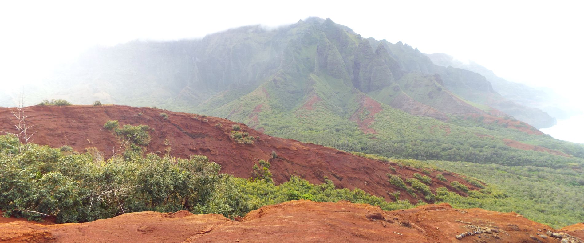
My first lifetime view into Kalalau Valley from the saddle of Red Hill:

Panoramic View into Kalalau Valley, now partially obscured by clouds (click to enlarge):
From the top of Red Hill, the trail needs to drop over 500 feet in elevation to reach Kalalau Beach:

Some of the best scenery of the whole trail is here in Kalalau Valley:


At the bottom of Red Hill is this grassy section:

The cliffs above Kalalau Valley are the most dramatic yet:

Reaching Kalalau Stream, the third major stream crossing on the trail. Kalalau Stream is the 10 mile marker on the trail:

My first view of the rocky section of Kalalau Beach:

The trail follows close to the rocky part of the beach as it heads for the sand:

Probably the most overgrown part of the entire trail is through here where there was a small muddy path passing through:

Waves breaking close to the rocky part of the beach:
Looking out at the crashing waves just off the beach:

Approaching the main part of the beach, sand starts to appear:


Just past some warning signs, the golden sand of Kalalau Beach becomes abundant:

A beautiful scene showing the Na Pali cliffs above Kalalau Beach:

The Kalalau Trail officially ends at this waterfall at the far end of the beach:

Kalalau Beach is one of the most pristine, isolated, and sought after beaches in Hawaii:
The spectacular beauty of Kalalau Beach is best enjoyed from the shore as there are riptides and strong currents:

Steve reaching his long-time goal of setting foot on Kalalau Beach, nearly 2 years after first researching the hike:


Taking a short break to appreciate the beauty and tranquility of the area. I had Kalalau Beach all to myself for about 30 minutes:

A self-portrait taken on Kalalau Beach:

Two final pictures of the sand and water at Kalalau Beach before beginning the long return hike:


Spotting a Red-crested Cardinal resting in the bushes along the trail. These birds are among the most colorful:

During the hike back, I had a chance to get some better pictures of the Eroded Cliffs section:

This picture gives a good indication as to the narrowness of the trail and the steep exposure of the Eroded Cliffs:

This sea arch can be seen below the Eroded Cliffs. Most people (including me) don't spot the arch until the hike back:
Another part I got better pictures of on the way back was Crawler's Ledge, seen here:


Looking straight down from the middle of Crawler's Ledge. Those with fear of heights have a hard time here:

A picture of Steve watching his footing closely on Crawler's Ledge:

Heading back into Hanakoa Valley after climbing the Muddy Switchbacks:
Soon, the light began fading and the sun set over the Na Pali Coast:

