


TRIP REPORT PHOTOS
Before carrying out the hike, we stopped at the Kalaupapa Overlook, which has a stunning view of the Kalaupapa peninsula far below way in the distance:

Kalaupapa translates out to "level land resembling a flat leaf", which is a fitting description of this isolated peninsula:

Being surrounded by towering cliffs and ocean water, there are no roads to Kalaupapa. This viewpoint is the closest you can get by car:

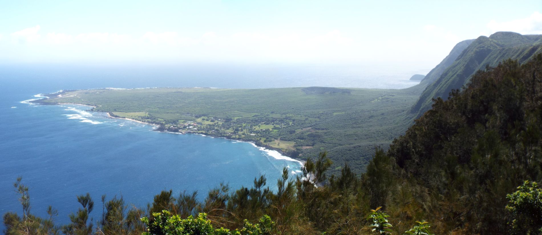
Full panoramic of the Kalaupapa peninsula as seen from Kalaupapa Overlook (click to enlarge):
The hiking route starts about 1/2 mile back down the road with a shady walk under some island trees:

For a short distance, you are walking along a 4WD road with trees on the left and pasture ground above the embankment on the right:

Soon there is another viewpoint of the peninsula, although not quite as sweeping as the main tourist viewpoint:

A picture of me at the official start of the Kalaupapa Trail:

The trail information sign has some details about the rules of visiting the peninsula and dangers along the trail while hiking:

The official trail begins with the terrain immediately becoming steep downhill hiking:

A second warning is posted here letting hikers know that the trail is only open to those with a paid permit:

Notice how the trail was cut through layers of soil at this spot, which has created an embankment on each side:

A very short distance into the hike, the most incredible viewpoint of the entire journey is reached. There are sweeping views from west to east. These are the towering cliffs to the west:

Looking straight down one of the tallest sea cliffs in the world while standing nearly 1,700 feet above the ocean:

Looking to the east, the Kalaupapa peninsula really stands out. Watch your step in this area as it is easy to get lost in the view:

A picture of Charlie with the Kalaupapa peninsula behind him:

A small wooden guardrail reminds you that there are dangerous cliffs on the left:

Enjoy every view that you can of the peninsula, because it frequently disappears from view for long stretches:

The only place where a wooden bridge has been installed. There must be a steep gully here or perhaps part of the trail washed out in the past:

The bridge is visible on the left as the trail quickly changes direction while continuously dropping elevation:

The next three pictures give you an idea as to the steepness of the trail. Notice that much like many of the trails in Yosemite National Park, the trail here is so steep that steps are cut into it to make it more manageable:

The one thing that is easily forgotten while heading down is that these same steps will have to be climbed back up later:

This switchback turn really feels unnerving while hiking down to it, with nothing but cliffs below:

The brief level stretches along the trail always provide a nice break for the knees:

Don't forget that these switchback are cutting in and out alongside steep cliffs above, so falling rocks are truly a danger:

Some stretches of the trail, such as this one, could get quite cramped when mules pass by. Keep in mind that mule teams always have the right of way when encountered:

Looking through the brush at the Kalaupapa peninsula, which is starting to look slightly closer:


The trail is just stunningly beautiful from beginning to end with such grand views in both directions while hiking along the cliffs:
Steps winding down through an area of lush greenery:

Reaching the #8 switchback marker, which helps you keep track of your progress both going down and coming back up:

The trail alternates between views like this (being enclosed by trees and brush),:

and views like this (where you can see either above the trees or through them):

A picture of me taken at the same spot as the previous picture. I liked this angle because it showcased both the trail steepness and the great views:

Waves breaking onto the shoreline far below and clouds above the Pacific way in the distance:


Hiking continuously downhill while dropping 1,700 feet can definitely take its toll, especially with endless steps:
The enchanting blue water of the Pacific is so enjoyable to look out to:

Charlie heading down the trail. Like me, he also fully enjoyed this trail and our visit to Molokai:

These are beautiful Pink Wood Sorrel wildflowers which were blooming along the trail:

Switchback marker #13 is the halfway point on the trail, since there are 26 switchbacks in total:

Being about halfway down now, notice how we were looking out toward the middle of the sea cliffs, rather than the upper portions:

The steepness literally never lets up until you near the bottom of the trail:

The trail works its way through or around several small ravines and gullies which flow down the hillsides:

From this turn on, the trail takes on a bit of different feel as there are lower elevation trees and more of a rocky path:

Several White-rumped shama birds were watching us hike along the trail:

White-rumped shamas are easy to recognize with white spots visible on the tail and backside of male birds:

The hillside through this area was strewn with boulders all over the place:

The peninsula looks so much closer now that we have dropped significant elevation:

The Molokai Light lighthouse is one of the most famous landmarks of the Kalaupapa peninsula:

The Molokai Light shines bright light for 20+ miles out to sea and has been doing so since 1909. The lighthouse has 189 steps and is 120 feet tall, which makes it the tallest lighthouse in Hawaii:

We did this hike at the very end of April, which meant fairly hot temperatures. But the heat was tempered by the great amount of shade along the trail:

As the blue water of the Pacific grew closer, we could now see and hear the sound of crashing waves far below:

There was a group of feral goats hanging out in this rocky area along the trail:

Continuing to appreciate the shade, since the air temperature was hotter at this lower elevation:

The trail was now just a short distance above the water level below:

The spot where the trail finally reaches sea level just above the beach:

The first beach area encountered is covered by round boulders which have been smoothed out by water and crashing waves:

Looking out at a small wave breaking just off the shore:

Looking to the east far down the beach, round boulders can be seen for quite a distance:

The trail is just above the beach lined with abundant boulders:

Looking back at the trail and majestic sea cliffs in the background:

More waves and white water just off the shore. This didn't look like a safe area to take a dip in the ocean:

The sea cliffs stretch on for miles toward the west:

Zooming in on the top of the cliffs, the Kalaupapa Overlook is located near the far right side of the picture:

The moon was rising above the pali (or cliffs), providing for remarkable photography:

Areas of sand started appearing along the beach:

Two more pictures showing the moon rising above some of the tallest sea cliffs in the world:


The sea cliffs drop abruptly and dramatically into the ocean below, as seen in the next two pictures:


Palm trees become part of the scenery during the beach portion of the hike:

The abundant rocks of the beach finally gave way to an abundance of sand:

This is a perfect area to take a relaxing break. Just keep an eye on the waves coming in so that you don't get caught unaware by a sleeper wave:


More beautiful palm trees line the western edge of the long beach:

In addition to the palm trees, other lush green trees provide welcome shade on a hot day:

The next two pictures show stunning Madagascar Periwinkle wildflowers which were blooming near the beach:


At the end of the trail, you enter into Kalawao County. A sign reminds hikers of the fines awaiting trespassers without permits:

To take the Damien Tours (which have obviously been named for Father Damien), continue along the roadside at the end of the trail:

The peninsula soon widens out and the far eastern cliffs become visible above it:

Looking up from this vantage point helps you to appreciate how patients of the leper colony must have felt being trapped with no way out of here:

Zooming in on a gorgeous waterfall dropping down the high cliffs. The Kalaupapa peninsula no doubt has many secret spots of great beauty:

The inhabited portion of the peninsula can be seen in the distance from this spot:

Zooming in on several buildings and facilities. While a few lepers still live here and receive treatment, they do so by their own free will:

As you hike farther along the peninsula toward the gathering spot for tours, the western sea cliffs can be seen more clearly:

Zooming in to appreciate the magnitude of the sea cliffs:

This sandy beach area is the prettiest spot along the bottom portion of the trail:

I stopped here briefly to rest during the early part of the return portion of the hike:

With the right lighting, the glistening sand shows off remarkable coloring:

One final look at the breaking waves and towering sea cliffs before beginning the 1,700 foot climb back:

The last two pictures show an adorable young goat which was playing along the trail during the hike back:


