


TRIP REPORT PHOTOS
The parking area for the hike is along Hwy 190 near the northernmost bend in the road within western Death Valley:

The aim spot to hike toward from the starting point is the left side of this round hill seen far in the distance:

This is the largest wash crossing during the journey across the Darwin Plateau:

Looking back toward the parking area and highway after crossing the largest wash:

Notice how the round hill has gotten a lot closer now. I continued to aim for the left side of it:

Olancha Peak (12,123 feet) in the snow-capped Sierras was visible from the plateau when looking to the west:

There were a few Joshua trees along this portion of the Darwin Plateau:

There were some really nice sections of terrain to walk on such as this area:

Reaching the round hill (which was reddish in color) and dropping into the wash leading to Lee Wash Main Side Canyon:

These rocks were buried in the wash at the head of the canyon:

First view looking into Lee Wash MSC from the canyon head:

View looking over the edge of the polished 1st major dry fall:

Looking down into the canyon below from along the western rim:

Walking a short distance along the western side and looking back at the 1st major dry fall and sheer cliffs:

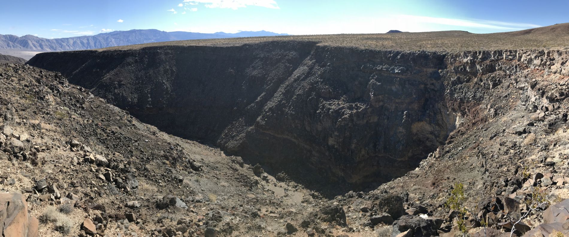
Panoramic showing the 1st major dry fall and eastern side cliffs of Lee Wash MSC (click to enlarge):
Next, I circled back around to the eastern side and continued along the canyon rim. Here is a view into the upper canyon which shows the last portion it would be possible to hike up later:

The walk along the canyon rim was quite easy with mostly flat terrain:

Looking into the middle canyon, there were soon glimpses of colorful canyon walls below:

Zooming in on some of the color bands for a closer look:

There were quite a few distinct color shades and layers of rock visible:

A nice view showing the inaccessible portion of upper canyon in between the 1st major dry fall and 2nd major dry fall. It does look like there might be a possible advanced bypass route on the right side, but it's such a short portion of canyon that I did not attempt it:

It is so impressive how the cliffs of the western side drop off in such dramatic fashion:

A long section of color bands visible. The color bands of Lee Wash MSC rival those of nearby Rainbow Canyon for beauty:

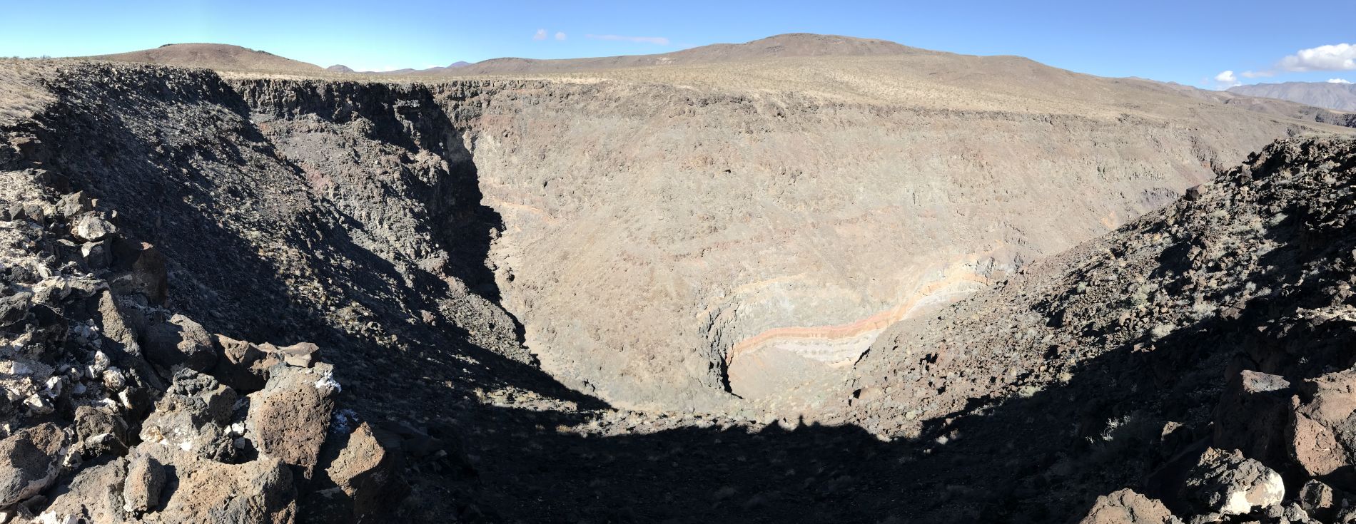
Panoramic looking back at the upper canyon and 1st major dry fall (click to enlarge):
Along the canyon rim, I would walk for a short distance and then go over to the edge and look down to see what I was missing:

At every viewpoint, a little bit more of the canyon below would open up and become visible:

The cliffs and hillside here have a combination of purple, pink, orange, and white:

In the next two pictures, notice how the entire hillside has been taken over by a variety of colors:

It looks like a giant natural painting with so many colors mixed together:

Panoramic of the middle canyon and expansive colorful hillsides far below (click to enlarge):

Many of the cliffs along this side of the canyon rim sloped down before dropping off vertically later:

The next six pictures show close-ups of some of the colorful hillside terrain seen far below:

A mixture of solid rock and dirt hillsides, all covered with a variety of colors:

Notice all the distinct layers of rock as well as the various textures:

What a striking contrast between the purple and orange rock colors:

A narrow band of red divides rock layers on the face of this cliff:

This section of hillside had rock outcroppings or colorful bumps as they appeared from a distance:

View showing the canyon floor and 1st major dry fall, which was now way in the distance:

Walking another section along the canyon rim:

The height of the canyon grew larger because the wash below kept dropping in elevation but the rim above stayed mostly level:

Approaching the end portion of the canyon rim walk as the terrain changes to large rocks everywhere:

A large part of northern Panamint Valley soon came into view:

The Panamint Sand Dunes were 5 1/2 air miles away from my location on the canyon rim:

Zooming in on some of the highest sand peaks of the Panamint Dunes. The highest point of the dunes can be seen at the back middle:

Coming up on the edge of the challenging bypass gully:

You can't enter the gully at the top because of a major dry fall. Instead, it is necessary to take this slope down on the left side:

Looking back at the major dry fall at the top of the gully:

The hillside terrain leading down into the gully wash is fairly steep:

Looking back up the gully, notice how the terrain is rough going:

The boulders in the wash make progress very slow and uncomfortable:

Near the bottom of the gully, the top of another major dry fall is reached:

Looking back up the long length of the bypass gully from the top of the 2nd dry fall:

Looking across at some of the steep slopes and drop-offs that lead to the canyon floor:

After turning to the right to get away from the dry fall, I found this steep slope which granted me access to the canyon bottom:

Having now arrived in Lee Wash MSC, I started by heading down canyon. Note the bottom layer of red rock on this canyon wall:

There were several formations in the lower canyon which I wanted to check out. I had spotted some of them 1 1/2 years earlier when passing by during our hike of Lee Wash:

A smaller canyon wall with a mixture of orange, red, and gray colors:

Dark red rock outcroppings on the right side of the canyon:

At the very bottom of the canyon, the hillside was taken over by these colorful formations:

As seen in the next two pictures, the lower formations were red, while the upper formations were a much lighter shade:


It is definitely worth it to hike to the bottom of the canyon to check out these formations:

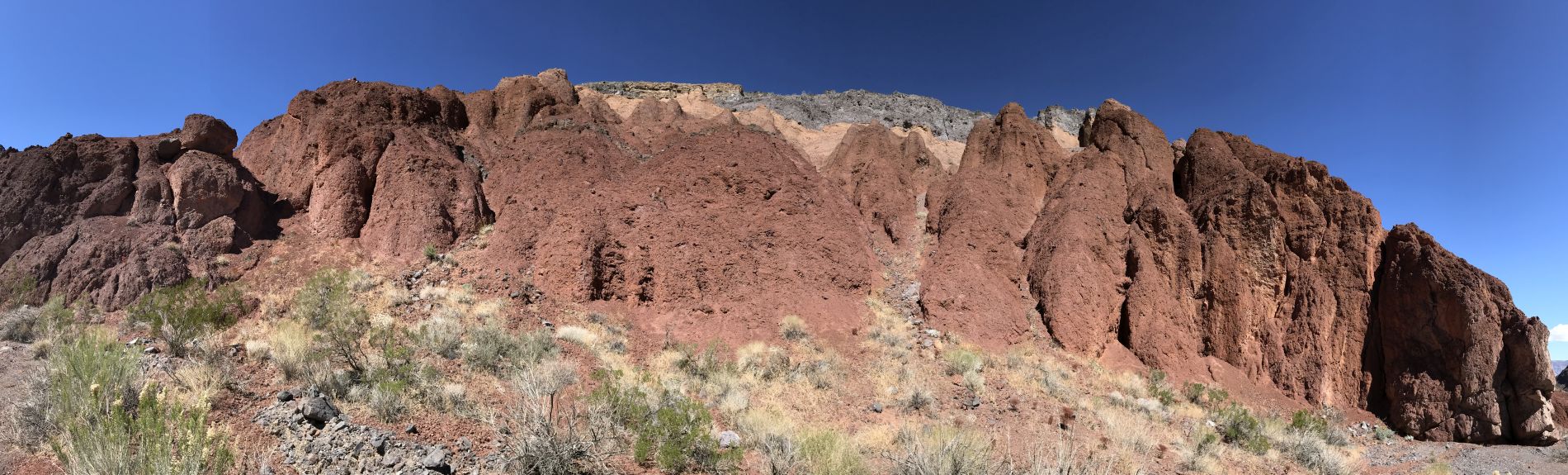
Panoramic of the unique colorful formations found near the mouth of the canyon (click to enlarge):
At the mouth of Lee Wash Main Side Canyon, this is the junction where it merges with Lee Wash:

Heading back up canyon now, I passed by this unique wall with a very jagged appearance:

On the left side, you can see the major dry fall which brings an abrupt end to the gully bypass route from above:

It was neat to finally be down in the canyon and heading up toward the beautiful spots I had seen from above:

The walls gave hints of what was to come with small sections of color bands and rock layers:

Soon, the scenery became more grand as the cliffs grew higher all around:

Even basic rock outcroppings were unique and interesting:

This canyon is probably seldom explored by hikers. I would think maybe once per year at the most. Or perhaps every few years:

This cliff face is located on the eastern side. A couple of hours earlier, I had been standing high above this spot:

Taking a closer look at the cliff face with color streaks and vertical drop-offs:

A mixture of red and purple smooth rock surrounded by jagged gray rocks:

This is such an impressive area to stand beneath. It's hard to believe how stunning a simple side canyon can be:

As I headed up canyon, I kept an eye out for potential exit routes to the top. But they were few and far between:

This is because the cliffs were so high and the slopes were too steep to climb up:

The rocks on this canyon wall look similar to those formed by columnar jointing:

Lee Wash MSC also had some nice sections of narrows to pass through, beginning here and continuing intermittently:

Encountering a minor dry fall which was necessary to climb:

I really like the variety on display at this spot with so many unique rock layers:

Climbing through some dry cascades in the narrows:

The solid rock extends across the bottom of the wash and connects the two sides of the canyon:

Passing through an enclosed area where some giant boulders have rolled into the wash:

A very pretty spot with a variety of rocks and cliffs all around:

The smaller canyon walls within the narrows were interesting to check out:

Looking back at the narrow passage I had passed through with colorful hillsides in the background:

A sharp narrow bend in the canyon up ahead:

Around the corner was this magnificent wall towering high above the wash:

A closer look at the cliff face which has so much variety on it:

The cliff face extended over to the right, where it curved and had a section that was broken off:

Panoramic of the eastern cliff face dropping off into Lee Wash MSC (click to enlarge):

Moving on in the narrows, there looked to be more outstanding scenery ahead:

A neat spot with bulgy orange rock transitioning into smooth rock with a combination of white and orange:

One of my favorite spots in the narrows where the passageway is tight with colors and rocks that blend together all around:

The orange and white rock wall extends above the canyon for a good length:

Really interesting shapes high up on the canyon wall:

A very special place in the narrows where the banded walls close in tightly together. Note the very dark rock along the bottom:


Climbing a gently sloped dry fall with the sun creating bright glows on the canyon wall behind:
The colorful bands and rock layers completely took over the canyon walls from here on:

As the canyon curves around, the bands follow along:

At least four very distinct rock layers can be seen here:

There aren't a lot of canyons like this where you get totally immersed in a world of colors for a lengthy stretch of canyon:

Orange, purple, and pink bands of color mixed in with various types of rock:

This giant amphitheater of rock marks the end of the passable canyon, about 1.8 miles from the mouth:

Taking a closer look at the 2nd major dry fall, which brought a definite end to the route:

The walls all around towered above and featured sheer vertical cliffs:

A very thick band of orange stood out on the canyon wall:

Heading back down canyon now through some incredible scenery:

Getting a picture in a beautiful section of Lee Wash Main Side Canyon:

The narrows through here were high enough to block out sunlight in the middle part of the day:

One more picture showing the contrast between the purple, orange, and white color bands on the walls:

After looking around for a while, I found a route up that I decided to attempt. It would have involved a lot of wasted effort had it not gone through. Here was my view looking up canyon as I climbed the steep slopes:

Climbing a little higher and looking back down canyon. What an incredible view:

Against all odds, I managed to make it to the top. But it wasn't easy. Near the center of this picture, you can see the 2nd major dry fall which had stopped the hike up canyon:

Looking across at the eastern canyon rim where I had been hiking along several hours earlier:

There was a great view of Telescope Peak, which was covered by snow in mid-March:

Zooming in on the mountains across Panamint Valley. The darker ridgeline in the middle leads up to Panamint Butte, while the higher ridgeline in the background leads up to Towne BM:

Two more pictures zooming in on Panamint Valley and the Panamint Sand Dunes:


The last picture really showcases the dramatic narrows and colors of Lee Wash MSC as seen from the western canyon rim:

