


Snow blanketed South Pass near the area where we parked:
View down Mill Canyon from South Pass toward Lake Hill and Panamint Dry Lake:
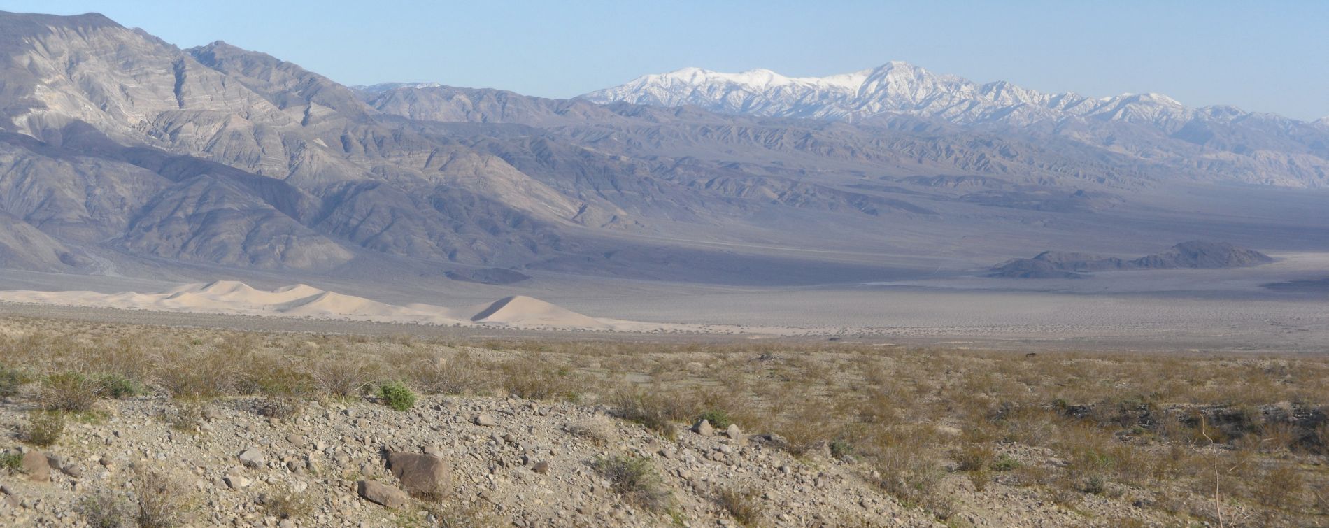
We turned off at South Pass and parked right at the beginning of the road up to Hunter Mountain. This was our first view as we began dropping down into Mill Canyon:
And another view about halfway down. The scramble down was a bit steep but relatively easy. There were faint trails to follow most of time as we switchbacked down:
Finally arriving in the wash of Mill Canyon:
The first thing we did was look down and notice a spring with very good water flow heading down the canyon:
Looking back up canyon at the point where we dropped in. We could see all the way up to the true head of Mill Canyon:
We were able to hike without any pressure, knowing that it was a one-way hike and we would be going downhill the entire day:
Most of the trees of Mill Canyon were bare, but their branches still provided a worthy obstacle to progressing through the canyon at times:
We soon realized that where we couldn't push our way through the branches, it was best to head up the hillside and bypass them, as we did here:
Three tall beautiful trees sitting in the middle of the canyon wash:
Continuing to follow the flowing spring in the next two photographs:
These are the mountain lion tracks mentioned in my introductory comments. They are claw markings from a cat that was moving briskly. Fellow hiker Patrick made the comment that "although we never saw the cat, I'm betting he had his eyes on us at one point." Very likely:
Two more pictures of the spring. It's amazing that the spring was flowing down the middle for the entire length of the canyon. I've never seen that before:
Another majestic tree with a snow-capped hillside in the background:
Check out this beautiful ice formation which has formed on a branch:
The first of quite a few small waterfalls that we would pass during the day:
Thick bushes and trees would crowd the narrow canyon wash on a regular basis, even more so the farther we progressed down canyon:
We always seemed to have a window through the canyon to see the Panamint Mountains:
Another small waterfall with quite a good flow:
Joshua Trees were a regular feature inside Mill Canyon:
Up until now, there were just dirt hillsides on both sides of the canyon. But soon we encountered the first of many rock walls:
Steve next to a large group of Mill Canyon Joshua Trees:
At times, Mill Canyon would make quick dramatic turns to the right or left. We found out that the easiest way to deal with this was to shortcut the turns by heading up the hillsides and hiking at a diagonal:
The next two pictures show the first significant waterfall that we encountered. Very easy to bypass and about 12 feet tall:
Check out how the canyon gets really narrow ahead as it enters a tight corridor:
Passing by two more significant waterfalls:
Look closely at the trail I'm following up in this picture and you can see that it is a clear path. The burros and wild cows who live in Mill Canyon maintain the bypass trails in the lower half of the canyon. They also destroy and trample on all of the vegetation:
To our surprise we came upon the ruins of an old building, which I'm going to refer to as the mill site:
The next six pictures give you a glimpse of just a few of the old rock foundation walls and artifacts which can be found around the mill site. There is more to see here. As usual, I purposely left some things out:
Does anyone recognize that peak far off in the distance? A very nice view of it from Mill Canyon:
Check out this massive pump/tank from mining efforts left behind:
The complexion of the canyon starts to change dramatically beyond the mill site ruins, as seen in the next two photos:
The next two photos show how thick the brush and trees got inside the canyon wash. Navigation became a lot slower for a while:
Heading into the gorge of Mill Canyon, which leads to the epic 50 foot waterfall:
As the water flows through the grass, it is making its way towards the edge:
And finally, the water plunges over this massive drop. This is a stunning visual sight in Mill Canyon:
Two more views carefully taken from the top of the Mill Canyon 50 foot waterfall:
And two pictures of Steve resting and looking over the drop. Thinking back, I probably should have stayed a few more feet back from the edge:
Heading down the relatively easy but slightly steep bypass to the northwest of the waterfall. This is looking down the first section:
Continuing on to the second part of the bypass. Keep in mind that while we felt the bypass was easy, others have called it hard, so use caution and determine if you feel it is safe before trying it:
Looking back at the bypass after we had finished scrambling down it. The bypass took us less than ten minutes to complete:
First view of the two-stage 50 foot waterfall of Mill Canyon:
The upper portion has a mossy drop, while the lower portion is just water flowing over slick rock:
At the base is this pretty pool. You can see that a good amount of water is dropping into it:
Two nice views of the entire waterfall in one picture:
Looking up at the waterfall from a different perspective, you can truly appreciate that it is a two-stage fall:
Four more unique views of Mill Canyon's crowning jewel. It's safe to say that this would be one of the park's top attractions if it was easier to reach:
The spring continues flowing down the lower canyon under this overhanging tree:
We soon met up with a few Mill Canyon residents -- two burros and one wild cow. Earlier in the hike, we had passed by two other wild cows:
Looking back at the high framed walls of the lower canyon:
Preparing to exit the canyon just up ahead:
Check out the tracks in the sand of the canyon wash. Mill Canyon definitely receives a lot of visitation, but not from humans:
Reaching the mouth of the canyon and looking into the distance to the south:
One final look back at Mill Canyon:
We next began hiking cross country toward the Panamint Sand Dunes. Because of the length of this report, I have included the last few pictures at the bottom of the Panamint Sand Dunes page. This is a panoramic view out toward Lake Hill. Our second vehicle was parked on the Lake Hill / Big Four Mine Road just north of Lake Hill (click to enlarge):
This rock wall provided a little bit of shade for a break:
TRIP REPORT PHOTOS