
MAPS

OVERVIEW
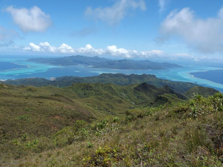
The Temehani Plateau is a beautiful high mountain plateau that contains extensive views all around Raiatea, of neighboring Tahaa, and of distant Bora Bora, as well as mountain streams, a stunning vertical lava tube, and the one of the rarest flowers in the world -- the Tiare Apetahi. Difficulties encountered on the hike include arranging for a hiking guide, avoiding hiking during times of rainy weather, dealing with heat and humidity, and being cautious when taking in views at the lava tube and along sheer cliffs. Topographical maps of the hiking route can be found by clicking on the buttons above. GPS coordinates for the starting point of the hike using the western route are -16.759996, -151.488702. GPS coordinates for the high point of the hike at 2,250 feet in elevation are -16.776869, -151.451138.
OUR VISIT
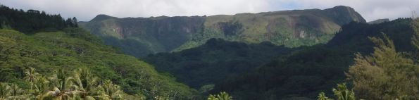
The hike to the Temehani Plateau is what I consider to be the best hike in the South Pacific out of the 22 major hikes that I have accomplished to date. While other hikes may have more impressive aspects to them (for instance seeing the view of Bora Bora from atop Mount Ohue), this particular hike cannot be topped for the exceptional overall experience from beginning to end. The lower portion of the trail immerses you in a world of abundant greenery, plants, and flowers, including passing through a forest of towering pine trees. The middle portion has refreshing mountain streams with freshwater eels, along with continuous sweeping views to the west and north which are wide-open due to the lack of trees. The upper portion wraps things up nicely with some very impressive natural features including rock slab cascades, a massive vertical lava tube, stunning views to the east and south, and the Tiare Apetahi, which is the holy grail of all South Pacific wildflowers to see in person. As you can tell from the brief summary, this hike is not to be missed if you can find a way to get to Raiatea, make arrangements with a hiking guide, and have weather good enough to carry it out. It should be considered mandatory to hire a hiking guide for this hike for several reasons. First, much of the trail passes through private property. The hiking guide will have been granted permission to pass through these areas of private property and thus you will not run into any problems on the way. Second, the route is not always straightforward. I noted during our hike that we passed several critical junctions, and we didn't always turn the way I was expecting us to. Thus, a hiking guide ensures that you will not get lost. Third, I found it very beneficial and rewarding to have a knowledgeable hiking guide explaining everything that we were seeing, and leading us to specific viewpoints and neat spots that would otherwise be missed. Fourth, without a hiking guide, you may not be able to find the Tiare Apetahi. There are no trail signs leading the way to locations of the rare flower. A guide can also help you to avoid accidentally trampling plants in threatened areas. Despite all of the other great aspects of the hike, viewing the Tiare Apetahi in person is the highlight of the hike.
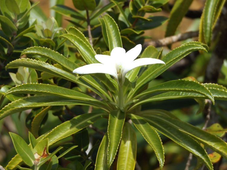
The Tiare Apetahi is known to be one of the world's rarest flowers. It is an extremely fragrant and beautiful flower, being shaped like an opened hand with five white petals. Sadly, it has been pushed to the edge of extinction. The Temehani Plateau can be divided into a northern section (Rahi) and a southern section (Ute). The northern section is open to the public and only has 5 remaining plants. The southern section is closed to the public and contains some 70 remaining plants. Plants also grow naturally on the nearby Tevaihue Plateau. All attempts made to grow the plant elsewhere have resulted in failure, as there is something about the soil, conditions, and environment which only allows the Tiare Apetahi to grow on the plateau. Currently, efforts are underway on the plateau to remove some of the invasive species and grow more plants. It is a huge time-consuming and expensive endeavor, but it will be well worth it if this beautiful plant can be saved to be enjoyed and appreciated by future visitors. Even young students on Raiatea have gotten involved in protection efforts, as a high school class finished up the 2017 school year by installing a metal fence high on the mountain in an effort to protect a single plant. Other than being crowded out by invasive species, what else has threatened the Tiare Apetahi? The illegal picking of flowers by hikers and poachers has been the main problem. In addition, pollution, insects, and rodents are also putting the flower at risk. During the twenty year period from 1995 to 2015, 81 percent of the plants disappeared. And protecting the Tiare Apetahi even now has not been without problems. For instance, in July of 2017, a thoughtless hiker destroyed other plants in trying to blaze a new trail to reach one of the Tiare Apetahi plants. Being that there are 33 other endemic plants at risk, some of which actually help the Tiare Apetahi to regenerate, this was a careless act of destruction. (As a side note, such a destruction of habitat is punishable by a fine of $10,000 and 3 months in prison.) The environmental protection associations of Raiatea state that: "By destroying vegetation by cutting or even trampling, you participate in the extinction of these unique plants in the world, most of which only exist on these plateaus." So please keep these things in mind when walking in the natural growing area of the Tiare Apetahi.
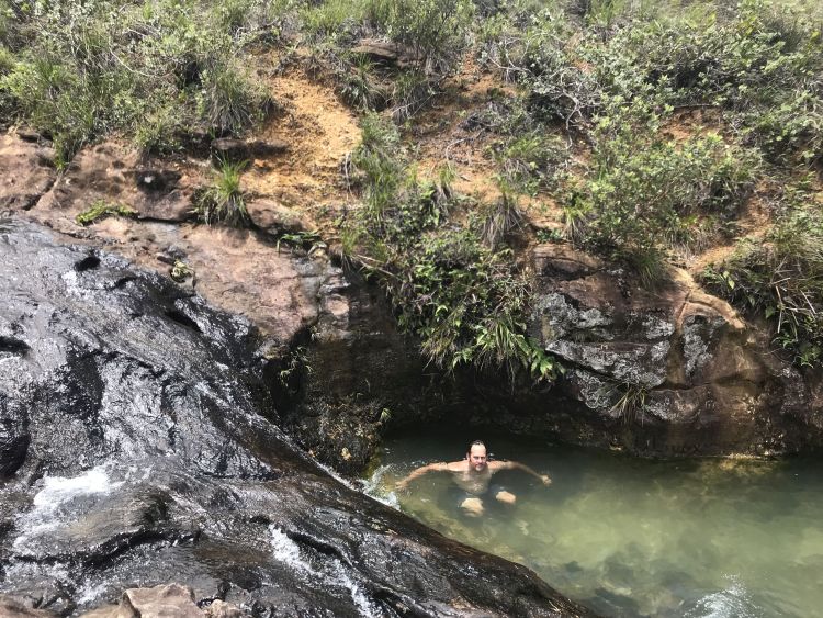
According to my topographical map, there are two main routes which can be used to reach the Temehani Plateau. One route starts from the west and one starts from the east. (In addition, there is another route which starts from the northwest which eventually joins up with the eastern route.) For a hiking guide, we used Kiam from Villa Temehani, which was where we stayed for lodging. After parking not far from the villa, we set out on the main western route. The rough road we were hiking on passed by a few houses as it began climbing. It wasn't long before we had our first view overlooking the small bay below us. After that, the views were kind of limited for a while as we enjoyed an array of greenery, flowers, and jungle plants in the rainforest. It was surprising a short time later when we entered into a thick forest of towering pine trees. Apparently, pine trees (as well as a few other fast-growing, thick-trunk trees) were introduced to Raiatea decades ago in an effort to produce local lumber. However, this plan backfired when the trees spread out of control and ended up causing habitat destruction. After passing through an area of free-roaming horses, the rough road transitions into a hiking trail. Next, there is a slight downhill portion along the main ridge within a thick portion of trees with no visibility. But then the trail climbs up, crosses a mountain stream, and the stunning views begin. Upon reaching the stream, we took a short break and cooled off in the refreshing water. This was absolutely necessary as we were hiking in the heat and humidity of summertime. The views start out to the west and include the distant but impressive silhouette of Bora Bora. Soon, there are views to the north of neighboring Tahaa and the high mountains there including Mount Ohiri. It is also neat to see the reef outline along the edges of the enclosed shared lagoon. There are very few tall trees beyond the first major stream crossing, so the views are continuous and will truly leave you awestruck. Eventually, an informational sign is passed and the high point of the hike is reached at 2,250 feet in elevation. Thereafter, there are views to the east and south. A couple of interesting natural features are then passed. The first is a pretty cascade that flows down grooves in a giant rock slab. The second is a vertical lava tube that captures a flowing stream. The lava tube passes deep down into the mountain and eventually releases the stream water thousands of feet below into the lagoon. It is a very strange feature that is surprising to find so high up on a mountain. The views at the end of trail stretch all the way to Mount Tefatua (also known as Mount Toomaru), the highest point of Raiatea and all the Leeward Islands at 3,337 feet. Mount Oropiro can also be seen farther to the south at 2,703 feet. The final part of the hike involves backtracking a little bit. There is a place to take a dip in a natural pool and stream which has freshwater eels in it. And last but not least, paying a visit to the Tiare Apetahi. Seeing the rare flower was a great way to end my fourth lifetime trip to the South Pacific. Our hike took place on January 9, 2018.
The Tiare Apetahi is known to be one of the world's rarest flowers. It is an extremely fragrant and beautiful flower, being shaped like an opened hand with five white petals. Sadly, it has been pushed to the edge of extinction. The Temehani Plateau can be divided into a northern section (Rahi) and a southern section (Ute). The northern section is open to the public and only has 5 remaining plants. The southern section is closed to the public and contains some 70 remaining plants. Plants also grow naturally on the nearby Tevaihue Plateau. All attempts made to grow the plant elsewhere have resulted in failure, as there is something about the soil, conditions, and environment which only allows the Tiare Apetahi to grow on the plateau. Currently, efforts are underway on the plateau to remove some of the invasive species and grow more plants. It is a huge time-consuming and expensive endeavor, but it will be well worth it if this beautiful plant can be saved to be enjoyed and appreciated by future visitors. Even young students on Raiatea have gotten involved in protection efforts, as a high school class finished up the 2017 school year by installing a metal fence high on the mountain in an effort to protect a single plant. Other than being crowded out by invasive species, what else has threatened the Tiare Apetahi? The illegal picking of flowers by hikers and poachers has been the main problem. In addition, pollution, insects, and rodents are also putting the flower at risk. During the twenty year period from 1995 to 2015, 81 percent of the plants disappeared. And protecting the Tiare Apetahi even now has not been without problems. For instance, in July of 2017, a thoughtless hiker destroyed other plants in trying to blaze a new trail to reach one of the Tiare Apetahi plants. Being that there are 33 other endemic plants at risk, some of which actually help the Tiare Apetahi to regenerate, this was a careless act of destruction. (As a side note, such a destruction of habitat is punishable by a fine of $10,000 and 3 months in prison.) The environmental protection associations of Raiatea state that: "By destroying vegetation by cutting or even trampling, you participate in the extinction of these unique plants in the world, most of which only exist on these plateaus." So please keep these things in mind when walking in the natural growing area of the Tiare Apetahi.
According to my topographical map, there are two main routes which can be used to reach the Temehani Plateau. One route starts from the west and one starts from the east. (In addition, there is another route which starts from the northwest which eventually joins up with the eastern route.) For a hiking guide, we used Kiam from Villa Temehani, which was where we stayed for lodging. After parking not far from the villa, we set out on the main western route. The rough road we were hiking on passed by a few houses as it began climbing. It wasn't long before we had our first view overlooking the small bay below us. After that, the views were kind of limited for a while as we enjoyed an array of greenery, flowers, and jungle plants in the rainforest. It was surprising a short time later when we entered into a thick forest of towering pine trees. Apparently, pine trees (as well as a few other fast-growing, thick-trunk trees) were introduced to Raiatea decades ago in an effort to produce local lumber. However, this plan backfired when the trees spread out of control and ended up causing habitat destruction. After passing through an area of free-roaming horses, the rough road transitions into a hiking trail. Next, there is a slight downhill portion along the main ridge within a thick portion of trees with no visibility. But then the trail climbs up, crosses a mountain stream, and the stunning views begin. Upon reaching the stream, we took a short break and cooled off in the refreshing water. This was absolutely necessary as we were hiking in the heat and humidity of summertime. The views start out to the west and include the distant but impressive silhouette of Bora Bora. Soon, there are views to the north of neighboring Tahaa and the high mountains there including Mount Ohiri. It is also neat to see the reef outline along the edges of the enclosed shared lagoon. There are very few tall trees beyond the first major stream crossing, so the views are continuous and will truly leave you awestruck. Eventually, an informational sign is passed and the high point of the hike is reached at 2,250 feet in elevation. Thereafter, there are views to the east and south. A couple of interesting natural features are then passed. The first is a pretty cascade that flows down grooves in a giant rock slab. The second is a vertical lava tube that captures a flowing stream. The lava tube passes deep down into the mountain and eventually releases the stream water thousands of feet below into the lagoon. It is a very strange feature that is surprising to find so high up on a mountain. The views at the end of trail stretch all the way to Mount Tefatua (also known as Mount Toomaru), the highest point of Raiatea and all the Leeward Islands at 3,337 feet. Mount Oropiro can also be seen farther to the south at 2,703 feet. The final part of the hike involves backtracking a little bit. There is a place to take a dip in a natural pool and stream which has freshwater eels in it. And last but not least, paying a visit to the Tiare Apetahi. Seeing the rare flower was a great way to end my fourth lifetime trip to the South Pacific. Our hike took place on January 9, 2018.
SAMPLE PHOTOS
ALL PHOTOS
Many more photographs taken during our visit are available for viewing for this destination. To see all of them, choose one of the two options presented below. The two options are Slideshow viewing and Trip Report viewing. The Slideshow option allows for viewing larger images with an autoplay option and a full screen option (available on most browsers). This option works very well for large computer screens and tablets. The Trip Report option allows for viewing smaller pictures in a standard scroll-down format and enlarging of any panoramic photos taken during our visit. Click on the option of your choice to view all of our photos from this destination. The Slideshow format opens in a new browser window and the Trip Report format uses the same browser window for viewing.
SLIDESHOW FORMAT
TRIP REPORT FORMAT