We arrived at the Mount Robson Visitor Centre a week before our hike and had a perfect complete view of the summit:
Zooming in on the upper regions of Mount Robson and glaciers on top:
Steve and Stefan on the back deck of the Visitor Centre on a beautiful day:
Stefan playing on the grass out front:
One week later, the weather was dreary. So we packed our umbrellas and ponchos, and began by crossing the Robson River:
Looking out at the Robson River from the center of the bridge:
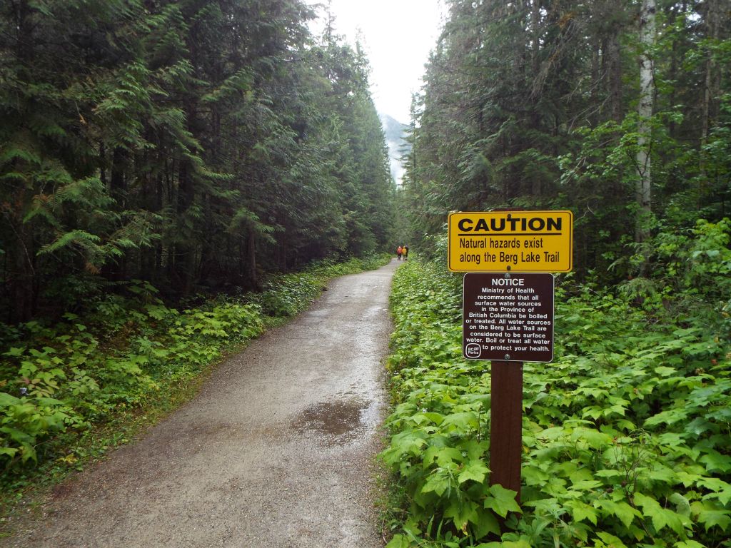
The first section of the Berg Lake Trail is heavily traveled with many day hikers heading to Kinney Lake. The trail is very well maintained:
Early on in the trail, the elevation gain is gradual and there are many views of the Robson River:
An early bend in the river as seen from the trail above:
The upper half of Mount Robson was not visible at this point. The weather was cloudy with light rain:
This part of the trail passes through an old growth cedar-hemlock forest:
Much of the time, the trail stays very close to the river:
Whitewater rapids provide for stunning scenery:
A picture of Steve next to the Robson River:
Abruptly, the river widens out and becomes more calm as we approach Kinney Lake:
Gary crossing over a bridge as the trail moves to the opposite side of the river:
Because Mount Robson is so high at 12,972 feet, it creates its own weather system. Out of nowhere, the clouds suddenly cleared and we had a perfect view of the summit:
Zooming in on the summit of Mount Robson as seen from the Kinney Lake bridge. This would be the last time we would see the summit on the trip:
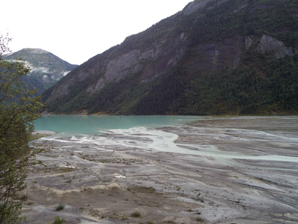
Notice the calm, beautiful blue water flowing out of Kinney Lake:
This shows a view we had of Whitehorn Glacier coming down from Whitehorn Mountain (located to the right but hidden in clouds):
We reached a clearing in the trees and had a nice view of Kinney Lake:
The trail continued to cut through the forest around the lake:
A picture of Gary at Kinney Lake. Kinney Lake is located about 4.25 miles from the starting point:
A panoramic of Kinney Lake taken from the shoreline near the campground:
Upstream of Kinney Lake, the Robson River divides into channels:
Several waterfalls flow down from the Cinnamon Peak area:
Crossing smaller creeks that drain into the Robson River:
The western peak of Campion Mountain is visible far in the distance:
An unusual bridge helps hikers cross the Robson River:
A pretty rockslide area. High above this small peak, Mount Robson is hidden in the clouds:
This view shows both of the twin peaks of Campion Mountain:
Gaining elevation now as we climb above Kinney Lake:
Notice the thick ground cover which shows how damp this forest is:
This suspension bridge near Whitehorn camp is one of the most well known spots along the trail:
A picture of Steve crossing the suspension bridge with his backpacking gear:
From the middle of the suspension bridge, this is the view looking up river:
Gary crossing the bridge carrying his hiking stick:
The terminus of Whitehorn Glacier is visible from Whitehorn camp:
Leaving the noisy and crowded Whitehorn campground behind and continuing on in our hike:
We were now entering the Valley of a Thousand Falls:
Looking up the Valley of a Thousand Falls, endless spectacular waterfalls can be seen cascading down the mountains:
The towering waterfalls seen in the next two pictures originate from glaciers high above:
Notice the contrast in colors as two water sources merge. The blue Robson River (bottom) joins with the grey creek flowing down the Valley of a Thousand Falls (top):
Another look at a waterfall that is just as spectacular as any found in Yosemite:
Our trail continued following the Robson River. A smaller waterfall could be seen here off to the right:
This smaller waterfall is the lower end of White Falls:
Crossing a bridge and preparing to do the most grueling part of the hike:
From the bridge to Emperor Falls, the trail gains about 1,700 feet over the next 3 miles:
Another view of the lower part of White Falls:
Gary taking a breather as we continued backpacking up the steep trail:
Looking back down as we worked our way up switchbacks:
Countless glaciers are visible below the peaks:
The Robson River plunges through the middle section of White Falls:
White Falls is the first of three major waterfalls the trail passes by during the steep climb:
Zooming in on the upper portion of White Falls through the trees:
A short time later, we arrived at the viewpoint for Falls of the Pool:
Arguably the most spectacular of the trailside waterfalls, Falls of the Pool cascades down over a steep drop:
Falls of the Pool drops through an enclosed passage naturally cut through the rock:
The pool at the bottom of Falls of the Pool:
One final view of Falls of the Pool before continuing on:
Off in the distance, we could see Emperor Falls, our destination for the night:
We stayed at the Emperor Falls campground. By the time we got here, it was dark out and so this picture was taken the next morning:
We woke up to a foggy, cold, wet morning. This view shows our tent space just above the Robson River:
It was very peaceful sleeping next to the sound of the raging river:
Leaving camp behind, I decided to day hike up to Berg Lake:
Looking back at the foggy valley of green grass and channels that I passed through:
Crossing over streams which are coming down from Hargreaves Lake and Hargreaves Glacier:
Upon arriving at the shoreline of Berg Lake, this was my view of Mount Robson. Not a very encouraging sign:
Even worse was this view of Berg Glacier across Berg Lake:
At least a small part of the shoreline was visible at the edge of the lake:
Since the entire lake was fogged in, I decided to climb up part of the Hargreaves Lake spur trail to see if there were any views above the fog. Soon, I could see more of Mount Robson:
And then the fog started lifting, allowing me to catch my first glimpse of Berg Glacier:
Rearguard Mountain popped out above the clouds:
My first panoramic of Berg Lake taken as the fog was lifting:
Berg Glacier comes steeply down Mount Robson right to the edge of Berg Lake:
I enjoyed the view from the vantage point for a while and kept waiting for a better look at Mount Robson:
I soon headed down to the trail which wraps around the lake and took it until I was directly across from Berg Glacier:
A panoramic showing Berg Glacier, Berg Lake, and the Berg Lake Trail:
The small summit visible in the middle of the picture is Mount Waffl:
More of Rearguard Mountain was now visible (peak on the left):
The clouds continued to hover towards the bottom and top of Mount Robson:
A nearly clear view of Berg Glacier:
Looking to the north, the far end of Berg Lake could be seen:
An iceberg floating in the lake. Berg Lake was named for the glacial ice which breaks off regularly and falls into the lake:
This was just about the best view I would have of Mount Robson on this day:
Zooming in on the beautiful stripes and patterns on the face of Mount Robson:
A panoramic showcasing much of Berg Lake:
There is a campground straight across from Berg Glacier which would provide a spectacular sight to wake up to:
A close-up view of how thick the ice is at the terminus of Berg Glacier by the lake:
Rearguard Mountain would make for a fun and challenging summit climb:
A picture of Steve taken at Berg Lake:
This panoramic was taken from the same fogged-in location where I stood much earlier:
View of Berg Glacier from the southern end of the lake:
Just barely visible under the fog is the bottom of Mist Glacier:
As I hiked back to camp, I took this long-range shot of Berg Glacier:
With that, we packed up camp and started backpacking to the car. Because it had been too dark the day before, we didn't have any good pictures of Emperor Falls yet:
Emperor Falls is quite majestic and is the only major waterfall that you can see up close:
Notice how Emperor Falls hits a rock ledge about halfway down, which causes it to spray out in a water wheel:
Standing right below Emperor Falls and getting sprayed by mist:
The report concludes with three views of Emperor Falls as we hiked back down the Berg Lake Trail towards Falls of the Pool: