
MAPS

OVERVIEW
Trellis Canyon is a very isolated and seldom visited canyon within Tucki Mountain which contains some nice sections of narrows and at least two confirmed dry falls. Difficulties encountered on the hike include route finding to access the canyon, hiking a long distance of 5 1/2 miles just to reach the mouth of the canyon, and overcoming dry falls in order to progress up canyon. A topographical map of the hiking route (turned to the northwest for better viewing) can be found by clicking on the button above. GPS coordinates for the canyon mouth are 36.543816, -117.059081. GPS coordinates for the Trellis Room are 36.517622, -117.071602.
OUR VISIT
Trellis Canyon is a very special place to me, one of the most special in the entire park. It is a place so isolated and unknown that most people have never even heard of it. My hike into Trellis Canyon was a turning point in my Death Valley adventures, as it served as a springboard into my exploration phase of the park. There is a long story behind my visit to Trellis Canyon, so I will try to start from the beginning. While carefully reading Michel Digonnet's guidebook 'Hiking Death Valley', I came across his brief mention of Trellis Canyon on page 390. On that page, he said three words about it, which were that Trellis Canyon was "well worth exploring". Digonnet also revealed the location of Trellis Canyon on the maps which he included in his book. Being that Trellis Canyon was a part of Tucki Mountain, it caught my attention. The main reason is that the Tucki Mountain canyons are among my favorite canyons in the park. Now that I've had a chance to fully explore Black Point, Stretched-Pebble, Lower & Upper Mosaic, Grotto, and Little Bridge Canyons, I can definitely say that they stand out in my mind for their great narrows and composition. Thus, I figured that I would find more of the same great things in Trellis Canyon. Digonnet further mentioned that he first came across the name of the canyon in a geology book by Hunt and Mabey called 'Stratigraphy and Structure, Death Valley, California', which was published in 1966. He added that one reason he recommended it in his book was that it was similar in setting and geology to other nearby canyons which he had visited, and it was very remote and hardly ever explored.
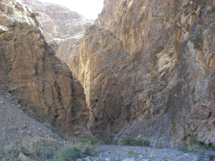
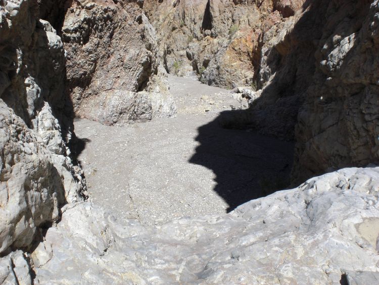
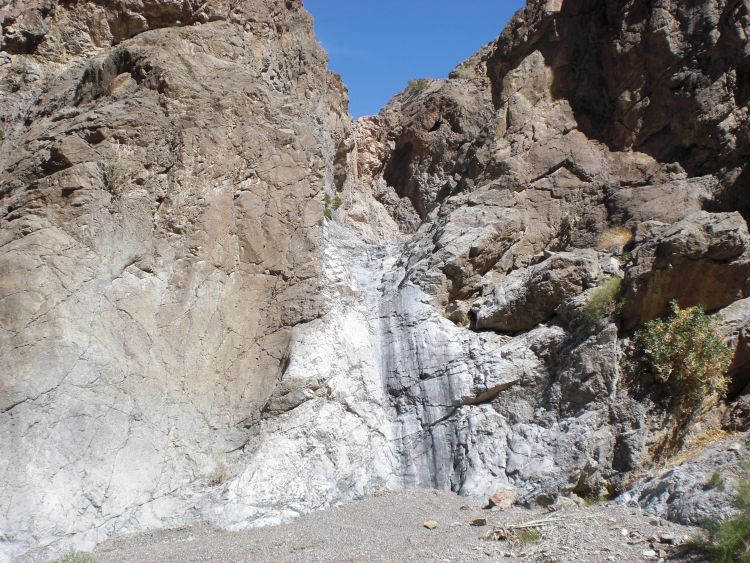
I first began thinking about exploring Trellis Canyon about six months before I did the actual hike. One of the first things I realized was that it would be an extremely long and difficult journey. The starting point for the hike would be at the Salt Creek parking area. From there, it would be necessary to navigate through the Salt Creek Hills and then up a long canyon fan which leads to the mouth of Trellis Canyon. This part of the journey alone would be about 5 1/2 miles long, which means there would be 11 miles of hiking that needed to be done which didn't include seeing the actual canyon. The question was -- how much energy would that leave for going into the canyon? And would we be able to do justice to the canyon once we got there? The answer proved to be a resounding yes, as Daria and I started out one morning and pushed ourselves to hike as fast as we could towards the canyon mouth. We arrived at the beginning of Trellis Canyon about 2 1/2 hours later. Once inside, this was our world to discover, as there was no information or maps anywhere which had details of what to expect in Trellis Canyon. About one mile in, we reached a junction, with the main canyon continuing to the right. Shortly after that, we entered the 1st set of narrows. The first thing we observed about the canyon before the narrows was that it had a lot of fluted mud cliffs, somewhat reminiscent of Nemo Canyon. From the narrows on, we observed that the canyon had more quick twists and turns than any other canyon we had ever hiked in Death Valley. And the narrows were long and thrilling to walk through. Over halfway through the 1st Narrows, we encountered a 12 foot dry fall that was somewhat challenging to climb. At this point, Daria decided to stop and wait for me in the canyon. She probably could have climbed it and continued with me, but it had been a long hike of 8 miles one way already, so she decided to rest for a while. I climbed over the 12 foot dry fall using some decent holds on the right side and continued until I exited the 1st Narrows. The canyon then opened up briefly, but soon entered a 2nd set of narrows. Once again, Trellis Canyon began its continuous twisting and turning, which made progress exciting every step of the way. In the 2nd Narrows, I passed by an interesting polished flat slab canyon wall, and then came into a room-like area where my journey ended. In this room-like area, there were a couple of dry falls, high cliffs all around, and plants growing out of the walls, which is something I had observed earlier in the canyon. The 15 foot dry fall which needed to be climbed to continue farther up canyon was a little bit too risky for me. A technical move is required which is similar to the part where you have to get around the chockstone in Red Wall Canyon. Thus my journey ended there in the Trellis Room of Trellis Canyon, after a hike of nearly 9 miles one way. There is probably a bypass somewhere outside of the Trellis Room but that search would have to be left for another day.
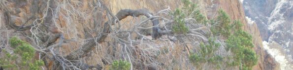
Why do I call this place the Trellis Room? In fact, to take this question a little bit further -- 50 years ago or more, why was this canyon named Trellis Canyon? I don't have the answer to that and I don't think anybody else does either, so that leaves me to speculate. There are not many definitions for the word "trellis", but one of them is "a structure of open latticework, especially one used as a support for vines and other creeping plants." One of the things I had noticed earlier in the canyon (you will see this in one of my pictures down below) and to a lesser degree in what I call the Trellis Room, is that vine-like trees and plants were growing in strange ways out of the canyon walls. The vertical walls are almost structured at times to provide support for the growth of these vine-like trees and plants. So in line with the definition, maybe somebody else noticed this long ago and named the canyon Trellis. Whatever the reason, Trellis Canyon is a great place. What makes it more special to me is the fact that besides myself and Daria, no other people are known to have hiked the canyon in the past decade. One person (a park ranger) did hike Trellis Canyon during the 1990s, but we became the first known people in the decade of the 2000s. After our hike, another group came through Trellis Canyon to look for The Scorpions and the entrance to the Lost City of Gold. But that's another story which I will share once I get the chance to hike the Trellis Main Side Canyon someday. Our hike took place on March 12, 2009.
I first began thinking about exploring Trellis Canyon about six months before I did the actual hike. One of the first things I realized was that it would be an extremely long and difficult journey. The starting point for the hike would be at the Salt Creek parking area. From there, it would be necessary to navigate through the Salt Creek Hills and then up a long canyon fan which leads to the mouth of Trellis Canyon. This part of the journey alone would be about 5 1/2 miles long, which means there would be 11 miles of hiking that needed to be done which didn't include seeing the actual canyon. The question was -- how much energy would that leave for going into the canyon? And would we be able to do justice to the canyon once we got there? The answer proved to be a resounding yes, as Daria and I started out one morning and pushed ourselves to hike as fast as we could towards the canyon mouth. We arrived at the beginning of Trellis Canyon about 2 1/2 hours later. Once inside, this was our world to discover, as there was no information or maps anywhere which had details of what to expect in Trellis Canyon. About one mile in, we reached a junction, with the main canyon continuing to the right. Shortly after that, we entered the 1st set of narrows. The first thing we observed about the canyon before the narrows was that it had a lot of fluted mud cliffs, somewhat reminiscent of Nemo Canyon. From the narrows on, we observed that the canyon had more quick twists and turns than any other canyon we had ever hiked in Death Valley. And the narrows were long and thrilling to walk through. Over halfway through the 1st Narrows, we encountered a 12 foot dry fall that was somewhat challenging to climb. At this point, Daria decided to stop and wait for me in the canyon. She probably could have climbed it and continued with me, but it had been a long hike of 8 miles one way already, so she decided to rest for a while. I climbed over the 12 foot dry fall using some decent holds on the right side and continued until I exited the 1st Narrows. The canyon then opened up briefly, but soon entered a 2nd set of narrows. Once again, Trellis Canyon began its continuous twisting and turning, which made progress exciting every step of the way. In the 2nd Narrows, I passed by an interesting polished flat slab canyon wall, and then came into a room-like area where my journey ended. In this room-like area, there were a couple of dry falls, high cliffs all around, and plants growing out of the walls, which is something I had observed earlier in the canyon. The 15 foot dry fall which needed to be climbed to continue farther up canyon was a little bit too risky for me. A technical move is required which is similar to the part where you have to get around the chockstone in Red Wall Canyon. Thus my journey ended there in the Trellis Room of Trellis Canyon, after a hike of nearly 9 miles one way. There is probably a bypass somewhere outside of the Trellis Room but that search would have to be left for another day.
Why do I call this place the Trellis Room? In fact, to take this question a little bit further -- 50 years ago or more, why was this canyon named Trellis Canyon? I don't have the answer to that and I don't think anybody else does either, so that leaves me to speculate. There are not many definitions for the word "trellis", but one of them is "a structure of open latticework, especially one used as a support for vines and other creeping plants." One of the things I had noticed earlier in the canyon (you will see this in one of my pictures down below) and to a lesser degree in what I call the Trellis Room, is that vine-like trees and plants were growing in strange ways out of the canyon walls. The vertical walls are almost structured at times to provide support for the growth of these vine-like trees and plants. So in line with the definition, maybe somebody else noticed this long ago and named the canyon Trellis. Whatever the reason, Trellis Canyon is a great place. What makes it more special to me is the fact that besides myself and Daria, no other people are known to have hiked the canyon in the past decade. One person (a park ranger) did hike Trellis Canyon during the 1990s, but we became the first known people in the decade of the 2000s. After our hike, another group came through Trellis Canyon to look for The Scorpions and the entrance to the Lost City of Gold. But that's another story which I will share once I get the chance to hike the Trellis Main Side Canyon someday. Our hike took place on March 12, 2009.
SAMPLE PHOTOS
ALL PHOTOS
Many more photographs taken during our visit are available for viewing for this destination. To see all of them, choose one of the two options presented below. The two options are Slideshow viewing and Trip Report viewing. The Slideshow option allows for viewing larger images with an autoplay option and a full screen option (available on most browsers). This option works very well for large computer screens and tablets. The Trip Report option allows for viewing smaller pictures in a standard scroll-down format and enlarging of any panoramic photos taken during our visit. Click on the option of your choice to view all of our photos from this destination. The Slideshow format opens in a new browser window and the Trip Report format uses the same browser window for viewing.
SLIDESHOW FORMAT
TRIP REPORT FORMAT