


OVERVIEW
The Kalalau Trail is an extremely challenging hiking trail which contains incredible views of the Na Pali Coast as it crosses several major streams, passes through multiple valleys, and follows along the edge of cliffs on its way to Kalalau Beach. Difficulties encountered on the hike are very numerous and are outlined below in the next section. Read the next section to become familiar with the safety hazards and ensure that you are well prepared and can handle the hike. Route maps and GPS coordinates are not provided because this is an official trail which is maintained by Hawaii State Parks. All hikers should obtain complete information on the hike and current conditions from Hawaii State Parks.
OUR VISIT
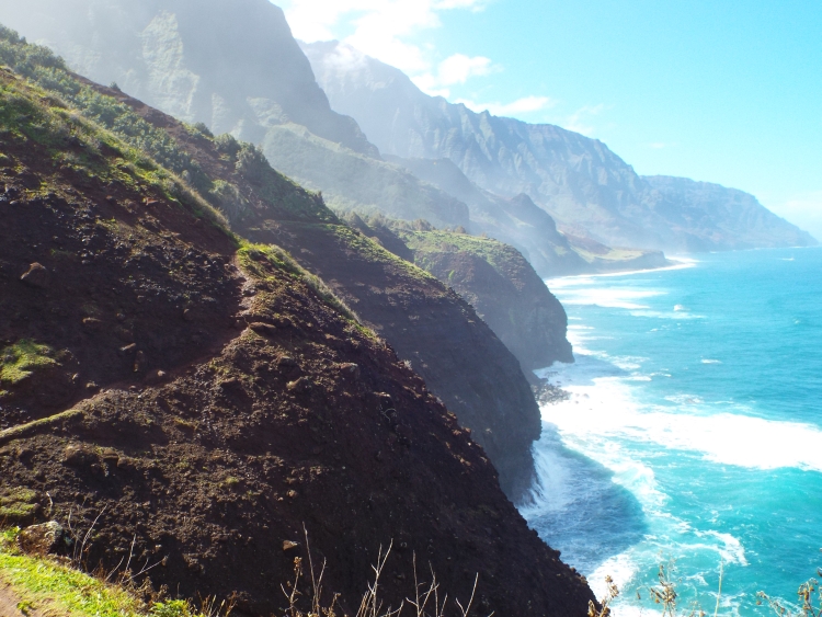
My plans to hike the Kalalau Trail in Kauai, Hawaii actually began with my hike of Buckskin Gulch in Utah. This is because the two hikes actually share something in common. While researching Buckskin Gulch for my summer 2012 hike, I came across an article in Backpacker Magazine which labeled it as one of America's 10 Most Dangerous Hikes. Out of curiosity, I checked out the other 9 hikes listed and found that one of them was the Kalalau Trail in Hawaii, which I had never heard of. As I did more research, I found out that the Kalalau Trail is widely regarded as Hawaii's best hike. That got my attention since I had never been to Hawaii before. At the same time, I found out that hiking the trail is extremely difficult because there are a variety of dangers throughout the hike. Before I go any further and discuss my successful hike of the trail, it is probably best to recap some of these dangers. The main concerns are (1) stream crossings, (2) ocean current and waves, (3) crossing exposed cliffs, (4) heat, humidity, and weather, and (5) falling rocks. Information about these dangers is widely available on other sites, but for the benefit of my readers, I will discuss them in more detail here. (1) There are three major stream crossings and countless minor stream crossings during the hike. The three major ones are Hanakapiai Stream, Hanakoa Stream, and Kalalau Stream. If there have been recent rains in the area (which is a normal occurrence), these streams can quickly rise in height and volume, making them dangerous to cross. Hikers have lost their lives attempting to cross them when it was not safe to do so. Hawaii State Parks recommends that hikers "avoid crossing swift flows when the water level is above your knees". Instead, it is suggested to wait for a while as the stream may quickly drop in volume once rain has stopped for a while. (2) There are two beaches which are visited during the hike -- Hanakapiai Beach and Kalalau Beach. Wading in the water or swimming is highly discouraged at both beaches and anywhere else along the route due to the dangerous ocean currents and intense waves. Signs are literally everywhere pleading with people to stay out of the water. Sadly, some have not heeded the warning signs and because of this there is another sign which keeps count of the large number of people who have drowned or been swept out to sea to their death. My visit took place in the winter and I could easily see how this could happen if someone were to get too close to the water. But, Hawaii State Parks warns that the "surf and currents are variable and can be treacherous even during summer". (3) The Kalalau Trail crosses several areas of high exposure where near-vertical cliffs drop hundreds of feet down into the ocean. To make things worse, if it has been raining recently, the narrow paths through these cliff areas can get muddy and slippery, increasing the likelihood of a fall over the edge. The three most intimidating spots of these exposed cliffs include the Muddy Switchbacks downhill after Hanakoa Valley (very muddy and treacherous after rains), the Crawler's Ledge (a section of solid rock with a very narrow passage and huge drop-off on one side), and the Eroded Cliffs above the sea arch (a narrow path above extremely exposed cliffs especially dangerous when muddy). None of these sections are very long but they are definitely best done when the trail is dried out. Each hiker will have their own subjective opinion as to the difficulty and danger that each of these sections presents. For me, I handled the Muddy Switchbacks with my trekking pole, I chose my steps carefully with attentiveness through the Crawler's Ledge, and I proceeded very slowly through the Eroded Cliffs but still nearly lost my footing once since it was muddy. However, what I found to be not overly challenging, others have been greatly intimidated by. I have read accounts of some hikers literally getting down on all fours and crawling across Crawler's Ledge. Others arrived at this section and did not even attempt it but turned around instead. During my return hike, I ran into a teenage girl who was visibly shaken up over crossing the Eroded Cliffs. In August of 2014, a hiker fatality occurred between mile marker 7 and Red Hill when someone fell from the exposed cliffs onto rocks 50 feet below. So each person will have to make their own decision based on current trail conditions as to what they can safely handle and how far they can get on the Kalalau Trail. One thing is certain, and that is that trekking poles are almost a requirement to carry out this hike safely and minimize the amount of falls that someone will take along the way. (4) As far as the heat, humidity, and weather, that should be the obvious part. Most hikers likely won't be able to hike as well as they can on the mainland. The humidity and heat during all seasons will require a slower pace and an abundance of water. Any drinking water obtained from streams needs to be treated due to the risk of contracting Leptospirosis. And if it is raining, that will make the stream crossings dangerous and the trail more treacherous. (5) Falling rocks are a concern as the trail winds through steep slopes and passes by some large rock outcroppings. It is even more of a concern for those attempting to take the side hikes to either Hanakapiai Falls or Hanakoa Falls. Pay attention while hiking and move quickly past any high-risk spots along the trail.
Warning signs at Hanakapiai Stream crossing --
Warning signs at Kalalau Beach entrance --


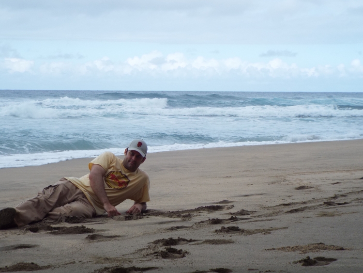
Now that I covered many of the potential dangers along the trail (Hawaii State Parks also mentions the threat of tsunamis, avoiding goat hunters, and staying away from mountain climbing), let me share the details of my own hike of the world famous Kalalau Trail. Being that this was our first trip to Kauai and Hawaii and we were only staying for 5 nights, I was not able to invest more than 1 day into the Kalalau Trail. Although this is usually done as a 2 or 3 day backpacking route, I needed to day hike it. Keep in mind that the Kalalau Trail is 11 miles long from the beginning at Ke'e Beach to the end of Kalalau Beach. Thus, it is a 22 mile round-trip hike. While hiking 22 miles in one day in the Sierras wouldn't be overly challenging, it is nearly impossible on the Kalalau Trail. These are not typical trail miles, but extremely hard miles due to constant ups and downs, very muddy and slippery conditions, and high heat and humidity. You simply cannot hike fast or you might slip off a cliff and tumble into the ocean if you do this hike in the midst of rainy weather. And that's exactly what I had during my hike. It had rained heavily the day before. While the sun was out for most of my hike, the trail was often very muddy. My hike began at 6:20am at the trailhead parking lot (which I had heard is a hotspot for vehicle break-ins) next to Ke'e Beach. Although parking spots can be hard to come by here, I managed to get one and start out my hike by flashlight. The hike began with the first part of the trail heading steeply uphill through mud and slippery rocks. After a very short time, I came to an immediate obstacle. There was a waterfall pouring water across the trail with a good amount of force. I figured that this had to be a bad sign. Since I had not found this obstacle even mentioned in any of my research, I figured it had to be a sign of heavy rains. After I made my way carefully across with my flashlight and trekking pole, I continued hiking uphill but began wondering if I would be able to safely cross Hanakapiai Stream when I likely reached it an hour later. I figured if I couldn't, then I could call off the hike and attempt it on another day of the trip. About 500 feet of elevation is gained over the first mile. That is followed by dropping that same 500 feet of elevation during the second mile. These first two miles took me 1 1/2 hours. That was a slow pace of 45 minutes per mile which surprised me. I thought I had been hiking fast, but obviously the muddy conditions and darkness had slowed me down. As I reached Hanakapiai Stream, it was now light out and I could see that the stream was higher than what I had seen in many pictures. I followed the stream down towards the ocean but could not see a way to safely cross by boulder hopping. Thus, I returned to the spot where the main trail met the stream and felt comfortable crossing there. The water depth reached a level of halfway between my knees and waist, but I never felt unsure of my footing or stability in the fast-moving stream. After crossing and putting my shoes back on, I walked down to check out Hanakapiai Beach. Sadly, there was no sandy beach to see. There was merely an abundance of rocks and continuous thundering waves. I'm assuming that the sandy beach was underwater during my visit due to the time of year being in the winter and perhaps high tide. Thus, I moved on in the hike and began climbing out of Hanakapiai Valley. The next mile (3rd) was perhaps the most strenuous of the hike, as I quickly gained 700 feet of elevation through a series of steep switchbacks. In the first three miles of the hike, I had already gained 1,200 feet of elevation. The high point of the entire trail is reached here as I passed through a spot known as The Gate. The moment I passed through The Gate and looked at what was on the other side, it took my breath away. The scenery of the mountains, peaks, and valley at that spot was stunningly beautiful. During the next two miles (4 and 5), I both dropped and gained elevation. By the time I arrived in Hanakoa Valley, my cumulative elevation gain was about 1,500 feet. Hanakoa Valley had another major stream crossing at Hanakoa Stream, but this one proved to be much easier. Either this area had received less rain the night before or the level of the water had simply dropped over the course of the morning. The next mile and a half (6 and part of 7) is spent climbing out of Hanakoa Valley and adding 300 feet of elevation. Hiking beyond Hanakoa Valley requires an overnight permit, which I had secured and paid for long before my trip took place. The next mile and a half (the rest of 7 and 8) is where the most treacherous spots are, including the Muddy Switchbacks, Crawler's Ledge, and Eroded Cliffs as mentioned earlier. This is also where the scenery becomes the most beautiful as the trail has incredible views of the Na Pali Coast to Kalalau Beach and beyond. Once I was past the hard parts, I was able to focus in on my next goal, which was to reach Red Hill. Red Hill is the final high point before the trail descends down to Kalalau Beach. About another 800 feet of cumulative elevation gain is added during the portion of the hike between Crawler's Ledge and Red Hill (located at about the 9 1/2 mile mark). Adding that up, that means that there is a minimum of 2,600 feet of elevation gained during the hike one-way from beginning to end. However, in view of the constant minor ups and downs, another source says that a more accurate number would be a total of 3,100 feet of cumulative elevation gain each way on the hike. Upon reaching the trail saddle of Red Hill, I knew that the end was finally in sight. Thus, I hiked down the steep red hillside, crossed Kalalau Stream, and walked onto the golden sand of Kalalau Beach. The hike had taken me about 7 1/2 hours one-way and I was completely exhausted. I spent about an hour snacking, enjoying the beach, and taking pictures, before beginning the long and arduous hike back. I had reached the legendary beach with its pristine sand and unmatched beauty. Kalalau Beach is considered by some to be the best beach in Hawaii. It certainly is among the most secluded and difficult to reach. Along with fellow hikers, you will also likely encounter people known as the Kalalau Outlaws during a visit to Kalalau Valley. The Kalalau Outlaws are a group of people who literally live in this area and survive off the land against the wishes of the park service. During my visit, I noted that one Outlaw was doing some maintenance work to assist hikers, while another was playing a homemade flute as he walked around the area. One other thing I should mention is that there was an endless amount of tour helicopters flying by during the hike. Literally every 5 to 10 minutes another one would disrupt the peace and quiet (and pleasant sound of birds) along the trail, and that surely will annoy a lot of hikers. For my hike back, I ran out of daylight just past Hanakoa Valley. I spent the final 5 1/2 hours of my journey hiking out in the dark. And it was almost nicer to do it that way. Not only was the temperature on the trail much cooler, but I enjoyed hearing the sounds of the Kauai night as I hiked by flashlight. To say that the return journey was difficult would be a major understatement. I was completely physically exhausted and barely made it out without having to rest alongside the trail and take a nap. Somehow, at exactly 12:00 midnight, I arrived back at the parking lot and drove back to my condo in Poipu Beach. My complete day hike of the Kalalau Trail had been one unforgettable adventure. The final stats of my hike of the Kalalau Trail were -- 264 photos (115 included in this report), 278 ounces of water (including 32 ounces filtered out of a stream), 22 miles, 17 hours 40 minutes (beginning at 6:20am and finishing at 12:midnight), and approximately 6,200 feet of total elevation gain (or 3,100 feet each way). My hike took place on January 30, 2014.
SAFETY ALERTS
This hike contains sections of exposed cliffs with steep vertical drops into the ocean, dangers from ocean currents and waves breaking on the shore, dangers from stream crossings with potentially high water levels, and challenges from heat, humidity, and muddy conditions. All hikers should use extreme caution and not attempt anything which feels unsafe. HIKER FATALITIES OCCUR NEAR THIS TRAIL EVERY YEAR.

SAMPLE PHOTOS

ALL PHOTOS
Many more photographs taken during our visit are available for viewing for this destination. To see all of them, choose one of the two options presented below. The two options are Slideshow viewing and Trip Report viewing. The Slideshow option allows for viewing larger images with an autoplay option and a full screen option (available on most browsers). This option works very well for large computer screens and tablets. The Trip Report option allows for viewing smaller pictures in a standard scroll-down format and enlarging of any panoramic photos taken during our visit. Click on the option of your choice to view all of our photos from this destination. The Slideshow format opens in a new browser window and the Trip Report format uses the same browser window for viewing.
SLIDESHOW FORMAT
TRIP REPORT FORMAT


